El mar del Norte es un mar abierto del océano Atlántico, situado entre las costas de Noruega y Dinamarca en el este, las de las islas Británicas al oeste, y las de Alemania, los Países Bajos, Bélgica y Francia al sur.
2007/12/23
Actualizar
Il Mar del Nord o Mare del Nord fa parte dell'Oceano Atlantico ed è situato tra le coste norvegesi e danesi ad est; le coste delle isole britanniche ad ovest; le coste tedesche, olandesi, belghe e francesi a sud; con il Mar di Norvegia a nord.
2007/12/23
Actualizar
La mer du Nord est une mer de l'océan Atlantique, située au nord-ouest de l'Europe. Elle communique avec :
la Manche par le pas de Calais au sud-ouest ;
la mer Baltique par le Skagerrak ou le canal de Kiel à l'est ;
l'océan Atlantique (mer de Norvège) au nord.
2007/12/23
Actualizar
The North Sea is a marginal sea of the Atlantic Ocean on the European continental shelf. It connects with the rest of the Atlantic through the Dover Strait and the English Channel in the south and through the Norwegian Sea in the north.
The Norwegian Sea (Norwegian: Norskehavet) is a marginal sea in the North Atlantic Ocean. It is located between the North Sea (i.e. north of Scotland) and the Greenland Sea and adjoins the North Atlantic Ocean to the west and the Barents Sea to the northeast. In the southwest, it ...
The Maunsell sea forts are a group of forts built during World War II. Today, they stand in the Thames estuary and are truly man-made islands that provide refuge for the local birds as well as a navigational guide for ships. Although not all of them still stand, there are plans ...
La côte belge est le nom généralement utilisé pour désigner la partie belge du littoral de la mer du Nord. Elle s'étend sur environ 66 km de long, de La Panne à Knokke-Heist. C'est une côte très urbanisée, avec beaucoup de grands immeubles à
appartements. La côte ...
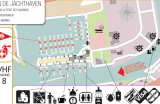
Petit port très abrité. Acceuil sympathique. Magazin libre service en haut du quai.
Fuel sur le ponton, essence à 100 m
sanitaire, douche, laverie
nombreuses balades
info 2012


 El mar del Norte es un mar abierto del océano Atlántico, situado entre las costas de Noruega y Dinamarca en el este, las de las islas Británicas al oeste, y las de Alemania, los Países Bajos, Bélgica y Francia al sur.
 Il Mar del Nord o Mare del Nord fa parte dell'Oceano Atlantico ed è situato tra le coste norvegesi e danesi ad est; le coste delle isole britanniche ad ovest; le coste tedesche, olandesi, belghe e francesi a sud; con il Mar di Norvegia a nord.
 La mer du Nord est une mer de l'océan Atlantique, située au nord-ouest de l'Europe.
 The North Sea is a marginal sea of the Atlantic Ocean on the European continental shelf. It connects with the rest of the Atlantic through the Dover Strait and the English Channel in the south and through the Norwegian Sea in the north.


