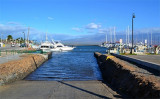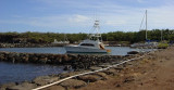

La perouse bay (Maui Hawaii)
4.5nm
114°
12 Dec 15
Joëlle
| Latitude | Longitude | |
| DMS | --- | --- |
| DM | --- | --- |
| DD | --- | --- |


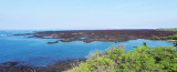
 Molokini is a tiny crescent-shaped island about three miles east
of Makena.Molokini Crater is what’s left from an eruption that is said to have
occurred around 230,000 years ago. The cinder cone created has since
been eroded to a crescent atoll.
Molokini is a tiny crescent-shaped island about three miles east
of Makena.Molokini Crater is what’s left from an eruption that is said to have
occurred around 230,000 years ago. The cinder cone created has since
been eroded to a crescent atoll.The little, uninhabited island has been fished, bombed, and finally protected as a Marine Life Conservation District.
Now the island is used primarily as a tourist destination for snorkeling, scuba diving, and snuba diving. Access for boats has been restricted to a certain amount of moorings. There is still some controversy as to whether the abundance of snorkelers is damaging the reef, and whether the constant visits of swimmers is affecting the marine life’s natural response to human contact.
Anchoring is forbidden. All boats are required to pick up one of the moorings provided by the state. The mooring floats are 3 meters beneath the surface so someone will need to dive down to retrieve the pennant. One is allowed three hours on a mooring.
The Coast Guard seems to drop by frequently.
You can only visit Molokini with a certified tour company. You may not walk on the islet itself.
")
")
Ebook | Hawaii
|