Le Golfe de Riga est profond de 67m au maximum.
Sa géographie particulière qui ne permet pas un grand brassage de
l’eau, amène à un taux de pollution plus élevé que dans la mer Baltique.
2011/07/26
Actualizar
Wikiadmin2
The maximum depth of the Gulf of Riga is 67 m. The island of Saaremaa (Estonia) partially separates it from the rest of the Baltic Sea. The main exit out of the gulf is the Irbe Strait. Ruhnu island, in the middle of the gulf, also belongs to Estonia. Notable cities in this gulf include Riga, Pärnu, Jūrmala and Kuressaare.
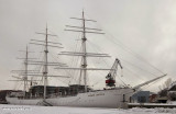
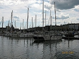
Naval museum where you can see the tall ship "Suomen Joutsen". She was built in 1902 by Chantiers de Penhoët in St. Nazaire, France, as Laënnec. In 1930 she became a school ship for the Finnish Navy.


 Le Golfe de Riga est profond de 67m au maximum.
Sa géographie particulière qui ne permet pas un grand brassage de
l’eau, amène à un taux de pollution plus élevé que dans la mer Baltique.
Le Golfe de Riga est profond de 67m au maximum.
Sa géographie particulière qui ne permet pas un grand brassage de
l’eau, amène à un taux de pollution plus élevé que dans la mer Baltique. The maximum depth of the Gulf of Riga is 67 m. The island of Saaremaa (Estonia) partially separates it from the rest of the Baltic Sea. The main exit out of the gulf is the Irbe Strait. Ruhnu island, in the middle of the gulf, also belongs to Estonia. Notable cities in this gulf include Riga, Pärnu, Jūrmala and Kuressaare.