Aroih Lampuyang is a rocky channel about 183 m wide, with a fairway depth of 20.1m. The passage should only be used by small vessels as the tidal currents are uncertain and the shoals bordering the fairway are unmarke.
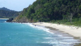
Pulau Nasi (Peunasoe or Aceh island), nearly joins the SE point of Pulau Breueh, being separated by Aroih Lam Puyang. The coast line is rocky in places with sandy beaches chiefly on the W side.
Lhok Prialaut is the bay lying between Ug Bau and Ug Seukundo. 6,5 NM appart, between wich points the bay extends S for about 4 NM, with Teluk Sabang on its E shore. Lhok Prialaut is about 2 miles in length and breadth, with good anchorage near its head, in 16.5 to 21.9m. Tides—Currents.—The ...
Pulau Keureuse (Nasi Kecil) or pulau Teunom, lies about 0.6 mile off the SW end of Pulau Breueh. A sand bank, with depths of less than 5.5m, extends NE for a distance of about 0.3 mile from the NE coast.
On the W side of Pulau Nasi is Lhok Pasijaning. During the Northeast Monsoon, there is good anchorage, in depths of 11 to 14.6m, fine sand. It is not available to anchor during the Southwest Monsoon.
Pulau Bunta (Pulau Boenta) lies between Aroih Raya and Aroih Cut (Aroih Tjoet).
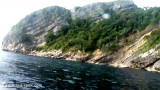
Pulo Bunta is the least interesting of the bigger islands in Pulo Aceh. It
has a light house and a few beaches, but difficult to swim due to the
barrier reefs and strong currents. There are no people ...


 Aroih Lampuyang is a rocky channel about 183 m wide, with a fairway depth of 20.1m.