Zincirbozan bank (Canakkale)

Zincirbozan bank (Canakkale)

To precisely geolocate this site. Update if necessary.

Localisation

Zincirbozan bank (Canakkale)
LatitudeLongitude
DMS------
DM------
DD------

Characteristics

Lighthouse

Description

Un haut-fond s'étend à l'extrémité N des Dardanelles. Le bord N du haut-fond est marqué par un feu qui est facilement repérable.
2010/06/5
Update
Joëlle
Zincirbozan bank (Canakkale)
2010-06-05
Update
Joëlle
Ebook

Marmara Denezi (NW Turkey)

  • 104 sites
  • 172 photos
  • publication date: 10 Jul 2023
  • .pdf file size: 72 Mb
Share your comments or photos on "Zincirbozan bank (Canakkale)"

Sites around Zincirbozan bank (Canakkale)

Flying distances - Direct line

Pasalimani adasi (Marmara adasi)

39nm
84°
Cette île se trouve juste en face de la côte W de la péninsule Kapidag. Elle est séparée de celle-ci par le chenal de Narliköy.
L'île est de basse altitude est couverte de cultures de vigne.
On trouve de nombreux mouillages tout autour de l'île.
7 Jun 10
Joëlle

Cardak banc (Canakkale)

2.6nm
230°
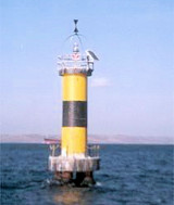
Le haut-fond de Cardak est situé au NE du phare de Cardak. Il est signalé par un feu constitué d'une tour à bandes jaunes séparées par une bande noire.Portée: 5MN.
5 Jun 10
Joëlle

Cardak feneri (Canakkale)

3nm
224°
It marks the beginning Cannakale N Strait in the Sea of Marmara.
Built in 1846, it is 9 m high and has a range of 6 NM.
5 Jun 10
Joëlle

Gelibolu feneri (Dardanelles)

3.3nm
258°
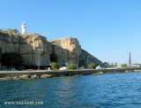
Gelibolu lighthouse is located on a promontory on the northwest side of the strait.
This lighthouse,built in 1856, marks the northern entrance to the narrow portion of the Dardanelles.
Site open, tower closed.  Construction:
Masonry round cylindrical tower with ...
5 Jun 10
Joëlle