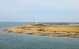
Le haut-fond de Cardak est situé au NE du phare de Cardak. Il est signalé par un feu constitué d'une tour à bandes jaunes séparées par une bande noire.
Cette île se trouve juste en face de la côte W de la péninsule Kapidag. Elle est séparée de celle-ci par le chenal de Narliköy. L'île est de basse altitude est couverte de cultures de vigne. On trouve de nombreux mouillages tout autour de l'île.
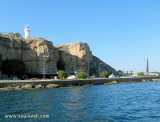
Gelibolu lighthouse is located on a promontory on the northwest side of the strait. This lighthouse,built in 1856, marks the northern entrance to the narrow portion of the Dardanelles. Site open, tower closed. Construction: Masonry round cylindrical tower with ...
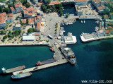
Le port est situé au S du phare de Gelibolu.Le mouillage dans le port est interdit. Le port de Lapseki est recommandé en alternative de Gelibolu.Les buildings de la ville de Gelibolu sont reconnaissables de loin, de même que le phare blanc de Gelibolu. De nuit utilisez le feu ...


")