W Hin Takon Dukang (Butang)

W Hin Takon Dukang (Butang)

To precisely geolocate this site. Update if necessary.

Localisation

Characteristics

Mooring
Sand
Diving
Fishing

Description

This anchorage, by 8/10 m, is just W of Hin Takon Dukang rock and is better in the southern season.
2011/11/28
Update
Jojo
W Hin Takon Dukang (Butang)
2011-11-28
Update
Jojo
Ebook

Andaman sea

  • 178 sites
  • 164 photos
  • publication date: 7 Jul 2023
  • .pdf file size: 54 Mb
Share your comments or photos on "W Hin Takon Dukang (Butang)"

Sites around W Hin Takon Dukang (Butang)

Flying distances - Direct line

Ko Adang (Butang)

2.6nm
327°
Ko Adang is a wooded island with a long white beach on the W coast. It is 30 km² and is part of National Natural Park.
28 Nov 11
Jojo

Ko Rawi (Butang)

6.9nm
298°
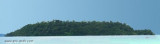
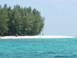
Big desert island, with a significant advantage over its cousins​​, that of having fresh water, Ko Rawi is located N of Ko Butang, E of Ko Adang. Its SE coast is populated with coral reefs and tropical fish.
28 Nov 11
Jojo

Ko Tanga and Ko Chuku (Taïland)

9.4nm
64°
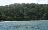
Koh Tanga and Koh Chuku, halfway between Butang and Tarutao offer great snorkelling, diving and fishing.
The best anchorage is found on the east or west coasts between the north and south Tangas, depending on wind direction and ground swell. Alternative daytime anchorage can ...
28 Nov 11
Jojo

Ko Butang (Butang)

8.5nm
274°
Ko Butang, with its reefs and white sand beaches, is SW island of Butang archipelago. 
28 Nov 11
Jojo

Ko Lipe (Butang)

1.3nm
217°
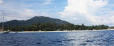
Koh Lipe is a small island in the Southern part of the Andaman sea. It is located in Satun Province, close to Langkawi island (Malaysia), about 60 Kilometres (38 miles) from the mainland.
It is part of the Tarutao National Marine Park, a large group of over 70 islands, and ...
27 Nov 11
Jojo

Ko Lipe North (Butang)

1.2nm
235°
Anchorage located opposite a Thai fishing station and a large sea gypsy village.We moor in 12/15 mon muddy bottom.
28 Nov 11
Jojo