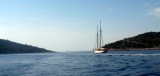
Uvala Tratinska is on the SW coast of O. Zirje. It is a large natural bay. As you approach the bay by the N, not to pass too close to Rt Ljuta due to a shallow area extending approximately 0.2 NM from the coast. This bay provides 22 mooring buoys near the restaurant that occupies the bottom of it. You can anchor in 6 to 14 m, with a line ashore by Bora. Sheltered from SW to E through the N.
2011/07/14
Update
Jojo
Uvala Tratinska se trouve sur la côte SW d'O. Zirje. C'est une baie naturelle importante.
En approchant de la baie par le N, ne pas passer trop près de Rt Ljuta à cause d'une zone peu profonde s'étendant sur près de 0,2 NM de la côte.
Cette baie offre 22 bouées de mouillage, près du restaurant qui occupe le fond de celle-ci.
On peut mouiller par 6 à 14 m, en portant une amarre à terre par Bora.
Otok Zirje
is the farthest and the largest island in the Sibenik archipelago. It is long of 6,5 NM (NW/SE) and 1,4 NM wide. The main village, Zirje, is located in the middle of the island. A small port, luka Muna, on the coast N of Zirje, home to the ferry that connects the ...
Kaprije is located in the central part of the Sibenik archipelago between the islands Zmajan and Kakan. The highlight of the island is Vela Glavica (132 m). The only village of the island is Kaprije, S. The port is busy. Automobiles are not allowed on the island.
Vrgadski Kanal, 7 miles long, leads between Otok Murter and Otok Vrgada and is the principal channel used in the S approach to Pasmanski Kanal and Zadar. Vessels with a maximum draft of 6.4m may pass through Pasmanski Kanal. Vessels with drafts over 6.4m must either proceed through ...
Zlarinski Kanal leads along the SW side of Otok Zlarin and is entered midway between Rt Rat and Otocic Komorica, a small islet marked by a light, 1.5 miles SW. This channel is sometimes used as an alternate route to Sibenik by vessels entering Sibenska Vrata, the middle passage, ...
Otok Svetac (Andrija), 305m high, lies 13 miles ESE of Otocic Jabuka and is generally steep-to. The coast of the island is rocky and reddish in color on the NW side. Its SW end is fronted by a few rocks. Hrid Kamik, a dark and jagged above-water rock, lies 0.7 mile W of the SW extremity ...
Otok Kakan, uninhabited, is at the W O. Kaprije. There is a nice anchorage on the E side, protected at the N by islands Borovnjak Veli and Borovnjak Mali.