Uvala Lojena Vela Smokvica Kornati

Uvala Lojena Vela Smokvica Kornati

To precisely geolocate this site. Update if necessary.

Localisation

Uvala Lojena Vela Smokvica Kornati
LatitudeLongitude
DMS------
DM------
DD------

Characteristics

Port quai
Mooring
Sand
Restaurant

Description

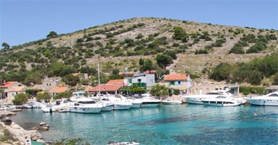
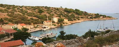
Bay is seasonally populated, with restaurant and water from the cistern.

Exposed to jugo; sheltered from the winds of the I and IV quadrant.

Berth: along the pier (quarter mooring by stern or by bow; Warning: depth 1.3 m).
Mooring: in the bay (on depths from 10-15 m).

Shallow: along the pier (depth 1.3 m). Warning: recommended approach to the bay is from SE direction.
With first signs of jugo one should move on the anchorage between islets Ravni and Kameni Žakan (W from Smokvica Vela);
(in the bay) undertow occurs after long lasting bora.

2011/07/19
Update
Jojo
Uvala Lojena Vela Smokvica Kornati
2011-07-19
Update
Jojo
La baie est saisonnièrement peuplée, avec restaurant et eau de la citerne.
Exposée à jugo; à l'abri des vents du quadrant I et IV.
Amarrage: le long du quai (amarrage par l'arrière ou par l'avant; Attention: la profondeur est de 1,3 m).
Mouillage: dans la baie (par des profondeurs de 10-15 m).
Hauts-fonds: le long du quai (profondeur 1,3 m). Attention: l'approche recommandée pour la baie est de direction SE.
Avec les premiers signes de jugo on doit passer à l'ancrage entre les îlots Ravni et Kameni Zakan (à l'W de Smokvica Vela); (dans la baie) un ressac survient après une Bora de longue durée.
2011/07/19
Update
Jojo
Uvala Lojena Vela Smokvica Kornati
2011-07-19
Update
Jojo
Ebook

Srednji Kanal

  • 44 sites
  • 61 photos
  • publication date: 9 Jul 2023
  • .pdf file size: 15 Mb
Ebook

Dalmacija (Dalmatie)

  • 542 sites
  • 910 photos
  • publication date: 9 Jul 2023
  • .pdf file size: 302 Mb
Share your comments or photos on "Uvala Lojena Vela Smokvica Kornati"

Sites around Uvala Lojena Vela Smokvica Kornati

Flying distances - Direct line

Otok Zirje (Sibenik)

9.7nm
117°
Otok Zirje is the farthest and the largest island in the Sibenik archipelago.
It is long of 6,5 NM (NW/SE) and 1,4 NM wide.
The main village, Zirje, is located in the middle of the island. A small port, luka Muna, on the coast N of Zirje, home to the ferry that connects the ...
16 Aug 11
Croatia

Otok Murter

7.4nm
54°
The island of Murter is the largest island of the Sibenik archipelago. It is close to the coast on which it is connected by a bridge, low air draft at Tijesno (Tisno) on the continent. During the summer the bridge opens to allow passage of boats.
The NW part of the island is fertile ...
3 Apr 11
Jojo

Vrgadski Kanal

8nm
16°
Vrgadski Kanal, 7 miles long, leads between Otok Murter and Otok Vrgada and is the principal channel used in the S approach to Pasmanski Kanal and Zadar.
Vessels with a maximum draft of 6.4m may pass through Pasmanski Kanal. Vessels with drafts over 6.4m must either proceed through ...
16 Jul 11
Jojo

Novigradsko More

28nm
Novigradsko More, a landlocked bay, lies at the S end of Novsko Zdrilo and provides good anchorage.
Rijeka Zrmanja flows into the bay at the E side. This river is navigable by small craft as far as the village of Obrovca, 6 miles above the mouth.
Luka Novigrad, a narrow inlet, ...
23 Jul 11
Jojo

Otok Kaprije (Sibenik)

9.8nm
101°
Kaprije is located in the central part of the Sibenik archipelago between the islands Zmajan and Kakan.
The highlight of the island is Vela Glavica (132 m).
The only village of the island is Kaprije, S. The port is busy.
Automobiles are not allowed on the island.
16 Aug 11
Croatia

Otocic Vela Smokvica Mala Smokvica Kornati

0nm
62°
O. Vela Smokvica and Mala Smokvica island are located S of O. Kornat, SW of Rt Opat.
O. Vela Smokvica, uninhabited, has an area of 1.04 sq km and its length is 6.17 km of coastline. The highest peak (Veli) is 95 m high.The island has a lighthouse at the N and offers a bay (Lojen) ...
19 Jul 11
Jojo