O. Vela Smokvica and Mala Smokvica island are located S of O. Kornat, SW of Rt Opat. O. Vela Smokvica, uninhabited, has an area of 1.04 sq km and its length is 6.17 km of coastline. The highest peak (Veli) is 95 m high.
The island has a lighthouse at the N and offers a bay (Lojen) in S.
Shallows: many around the island; on E side there are two (of 2 m and 3
m). Warning: around 650 m ESE (from the islet Smokvica Mala) there is
an unmarked reef.
2011/07/19
Update
Jojo
O. Vela Smokvica et l'îlot Mala Smokvica se trouvent au S de O. Kornat, au SW de Rt Opat.
O. Vela Smokvica, inhabitée, a une superficie de 1,04 km² et sa longueur de côte fait 6,17 km. Le plus haut sommet (Veli) fait 95 m de haut.
L'île porte un phare au N et offre une baie (Lojena) au S.
Hauts-fonds autour de l'île: sur le côté E, il y a deux (2 m et 3 m). Attention: à environ 650 m à l'ESE de l'îlot de Mala Smokvica il y a un récif non signalé.
Otok Zirje
is the farthest and the largest island in the Sibenik archipelago. It is long of 6,5 NM (NW/SE) and 1,4 NM wide. The main village, Zirje, is located in the middle of the island. A small port, luka Muna, on the coast N of Zirje, home to the ferry that connects the ...
Vrgadski Kanal, 7 miles long, leads between Otok Murter and Otok Vrgada and is the principal channel used in the S approach to Pasmanski Kanal and Zadar. Vessels with a maximum draft of 6.4m may pass through Pasmanski Kanal. Vessels with drafts over 6.4m must either proceed through ...
Novigradsko More, a landlocked bay, lies at the S end of Novsko Zdrilo and provides good anchorage. Rijeka Zrmanja flows into the bay at the E side. This river is navigable by small craft as far as the village of Obrovca, 6 miles above the mouth. Luka Novigrad, a narrow inlet, ...
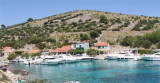
Kaprije is located in the central part of the Sibenik archipelago between the islands Zmajan and Kakan. The highlight of the island is Vela Glavica (132 m). The only village of the island is Kaprije, S. The port is busy. Automobiles are not allowed on the island.
Bay is seasonally populated, with restaurant and water from the cistern.
Exposed to jugo; sheltered from the winds of the I and IV quadrant.
Berth: along the pier (quarter mooring by stern or by bow; Warning:
depth 1.3 m). Mooring: in the bay (on depths from 10-15 m). Shallow: ...
O. Ravni Zakan is located SW of the point S of O. Kornat, betweenO. Skulj and O. Lunga at the W. This island have two bays where anchorage is possible and a port.