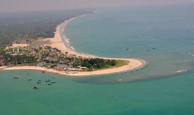
Pulau Wunga (W Nias)
24nm
310°
A large conspicuous tree, visible for 16 miles, is located on a small elevationnear the N end.
The reef extending from the N side of the island is ordinarily marked by high rollers; on the S side ...
6 Feb 12
Jojo
| Latitude | Longitude | |
| DMS | --- | --- |
| DM | --- | --- |
| DD | --- | --- |

 Tanjung Sirombu, lying about 34 miles SSE of Tanjung Sosilutte, is low and wooded and may be identified by several tall casuarina trees which stand above the other trees. The point is marked by a light. From a distance it resembles an island, but from closer in the low wooded sandy isthmus joining it to the land is visible.
The coast is indented for about 33 miles SE from Tanjung Sirombu to Tanjung Lauju, the SW extremity of Pulau Nias. Tanjung Lauju is low, but rises gradually to 110m.

Ebook | Sumatra (Indonesia)
|


