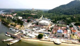
The Lumut Waterfront is a recently new build park on the north
side of the little town of Lumut, next to the Lumut is the International
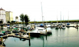
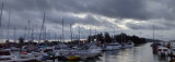
Yacht Club or marina Wing.Yachts can berth at the International Yacht Club Marina or anchor off and, for a charge, use their facilities. There ...
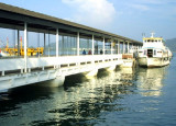
Lumut is a coastal town in the state of Perak in Malaysia and is the gateway to Pangkor island. It is a quaint little town famous for its beautiful seashell and coral handicrafts. This once little-known fishing town has since become the Lumut home biggest base of the Royal Malaysian ...
Pulau Tukun Perak (Fairway Rock) 5.5m high lies about 4 miles SSW of Southeast Point on Pulau Pangkor. A wreck, with a depth of 9.5m, lies 1.75 miles ENE of Pulau Tukum Perak.
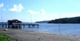
Located E coast of Pulau Pangkor in a shallow bay Port Pangkor, in front of Pangkor village, has a small jetty, with a depth of 6,1 m alongside.Tides_Currents:The flood runs S, and the ebb N along the W coast of Pulau Pangkor. taking the direction between Pulau Pangkor and Pulau Pangkor ...


 Tanjong Katak is low and continues to the entrance of the Sungai Perak (Perak River), located about 14 miles SSE of Pulau Pangkor.