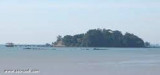

Water islands (Malacca - Malaysia)
7.7nm
144°
The Water Islands, centered about 8 miles SE of Melaka, consists of a group of six tree-covered islands of moderate ...
5 Jan 12
Jojo
| Latitude | Longitude | |
| DMS | --- | --- |
| DM | --- | --- |
| DD | --- | --- |


")
 The town of Melaka (Malacca), capital city of the Malaysian state of Melaka, stands on both banks of the Melaka River which discharges about 6 miles E of Tanjong Keling, the two parts being connected by several bridges.
St Paul's Hill, wich is conspicuous, stands on the left bank of the river and is marked by the ruins of an ancient church and a disused lighthouse. A slender pointed roof stands near the coast about 0.5 mile NW of St. Paul’s Hill disused lighthouse.
It is conspicuous from the offing being the only structure which rises above the buildings in the town. A white cylindrical minaret with a pointed dome stands in a gap between the trees on the coast about 1.2 miles NW of the lighthouse.
Aspect.—Two tall buildings about 34.7m high stand about 1 mile ESE of St. Paul’s Hill.
Bukti China, an almost bare conspicuous hill, stands almost 0.75 mile NE of St. Paul’s Hill. Bukti Bruang, an isolated hill 156m high, and Bukti Sebukor, about 64m high to the tops of the trees, stand about 3.7 and 2.5 miles, respectively, NNE of St. Paul’s Hill. The country a few miles inland consists of undulating hills.
Gunong Ledang, which has a triple peak 1,275m high, stands about 24 miles NE of St. Paul’s Hill.
A conspicuous radio mast stands about 137m NNE of St.
Paul’s Hill disused lighthouse. St. John’s Hill, with the ruins of an old battery on it, stands 1 mile E of St. Paul’s Hill.
The coast near the town is low and wooded.
A stranded wreck is reported to lie about 0.1 mile off the breakwaters.
Beware: A vessel approaching Melaka Road from the W should pass not less than 2 miles S of Tanjong Keling and 1 mile S of Pulau Upeh to clear the off-lying dangers, and course should not be altered until St. Paul’s Hill bears less than 055°.
Approaching from the E, after passing Pulau Undan and Pulau Hanyut, the course should be altered to clear Foulerton Shoal and then altered for the anchorage. Small vessels frequently pass N of Pulau Besar and Pulau Panjang, but this route should not be used without local knowledge.
A depth of 19m was reported about 0.5 mile SW of Pulau Undan. There are numerous fishing stakes off the coast.
A vessel approaching from the SE at night should make Pulau Undan Light and after passing SW of it, and of Pulau Hanyut, should steer with the light bearing 135° astern, until the light on St. Paul’s Hill conspicuous radio mast bears 038°, when it should be steered for on that bearing which will lead to the anchorage. Alternatively, the breakwater head lights may be used as leading lights.
Pulau Undan Light will also be sighted when approaching the road from the NW,and may be steered for from abreast Tanjong Keling.
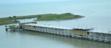
Melaka is a lighterage port where there is activity employing a total of 44 wooden lighters for the loading and discharging of ocean-going vessels. The harbormaster offices are situated in a building along the quay.
Tides—Currents.—The spring range of the tide is 1.8m; the mean tidal range is 1.3m.
Depths—Limitations.—The Tanjung Bruas jetty will accommodate vessels of up to 125m in length on the seaward side and vessels of 65m in length on the inner side. The depth alongside is 9m at LW.
An oil mooring, consisting of two head and two stern buoys, provides discharge to a local power station via a submarine pipeline.
Quays that line both sides of the Melaka River just within the entrance are principally used by lighters loading or discharging cargo for vessels in Melaka Roads. The landing place is the Government Jetty, a concrete public quay, on the E side of the river. The channel leading into the port area between two breakwaters has a least depth of 0.6m. Small vessels drawing up to 1.5m can enter the river at MHWN.
An area bordering the shore NW of the NW breakwater is being reclaimed.
Pilotage.—Pilotage is compulsory for all vessels. At least 4 hours notice should be given to the Melaka Port Authority.
Vessels coming from W are boarded 2.75 miles WSW of Tanjong Keling. Those from E are boarded 5 miles SSE of the same point. A private pilot is used at the offshore oil mooring.
The tidal current sets SE at a rate of 2.5 knots from 3 hours before to 3 hours after HW at One Fathom Bank; for the remaining 12 hours it sets to the NW at a rate of about 1.7 knots.
Anchorage.—In this open roadstead there is good anchorage, in from 5.5 to 14.6m, about 1 to 2 miles offshore.
")
")
Ebook | Strait of Malacca (East)
|