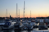
All visiting vessels must clear inwards at the main harbour of St Peter Port, regardless of whichever marina they moor in. Mooring in the QEII Marina is by prior arrangement only.
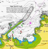
Visiting Tachts In the Victoria Marina: Moorings alongside pontoons are available for boats up to a maximum of 42ft (12.8m) LOA and a maximum draught of 6ft (1.8m). The sill height is 4.2m above chart datum, with access to the marina approximately 2.5 hours either side of high ...
Le Jaonnet and La Bette Bays situated in the NE corner of Icart Bay provide idyllic seclusion in calm light N -NE airs in 3.5-4m, sand. At the western side of the Bay lies a small but stoney picturesque cove at the foot of Petit Bot valley, again with a Martello Tower. A close ...
The Harbour office is open: June to August: 0800 – 2000; At all other times: 0800 – 1700 Monday to Friday;On arrival please call into the Harbour Office where our friendly and helpful staff will ensure that you have all the nautical, weather and general information required for ...