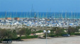
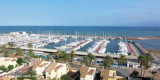
Cabo Canet (C Valenciana)
1.4nm
22°
25 May 12
Jojo
| Latitude | Longitude | |
| DMS | --- | --- |
| DM | --- | --- |
| DD | --- | --- |


")
")
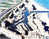
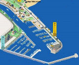
 The main acticité port, owned by an industrial company, is trading in iron ore.
The port is equipped with facilities for loading and unloading ore coal.
Caution: A shoal area, with a least depth of 1.6m, extends W from the W side of the breakwater and lies adjacent to the entrance channel.
An isolated patch, with a depth of 4.5m, lies about 0.2 mile S of the head of the breakwater.
Winds from the N or E may be strong enough to cause a troublesome swell in the harbor entrance and prevent entry or exit.
Three marine farms are established in the port of Sagunto.
 La principale acticité du port, qui appartient à une compagnie industrielle, est le commerce de minerai de fer.
Le port est équipé de moyens pour le chargement du minerai et le déchargement du charbon.
Attention: Une zone de haut-fond, à une profondeur de 1,6 m se trouve à l'W du côté W du brise-lames et est adjacent à l'entrée du chenal.
Un banc isolé, à 4,5 m se trouve à environ 0,2 MN au S de l'extrémité du brise-lames.
Les vents du N ou de l'E peuvent être assez fort pour entraîner une houle inconfortable dans l'entrée du port et empêcher d'entrer et sortir.
3 fermes marines s'étendent dans le port de Sagun.
Ebook | Espagne Est - East Spain
|