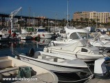
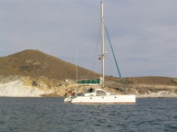
The large central pier was converted into a marina, many free places in June 2011. Fuels, water, electricity, sanitary, there is everything you need.
2019/06/6
Update
azerty
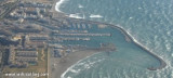
L'entrée du port est large de 90 m et profonde de4 à 6 m sur fond de boue.
T. 950 27 12 48
F. 950 32 01 44
Mail: cnrm@cajamar.es
Prof. aux pontons: 1,5 - 4,5 m
183 pl.
2019/06/6
Update
phil de tudo bem
Le grand quai central a été aménagé en port de plaisance, beaucoup de places libres en juin 2011. Carburants, eau, électricité, sanitaires, il y a tout ce qu'il faut.
2019/06/6
Update
phil de tudo bem
Benjamín Núñez González -CC BY
2019-06-06
Update
Anonymous
Share your comments or photos on "Puerto de Roquetas"
Marina located in the Gulf of Almeria, protected towards the SE by a breakwater. The entrance opens towards the SW, it is wide of 60 m, with a depth of 6.5 m, on bottom of rock and sand. Access: drive to the control tower at the port entrance.Attention to the marine farm installed ...
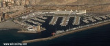
The entrance to this port has a width of 300 m and a depth of 10 m, descending between 2 and 8 m inside the port. The bottom is made of rock and sand. T. (+34) 950 23 07 80F. (+34) 950 62 11 47Mail: cma@clubdemaralmeria.com286 pl. (<15m)Max depth: 6.5 m
Description of the Region of Almerimar:
The town of
Almerimar is located on the Mediterranean.
This region "Costa de Almería" has a very moderate climate all year
round. This means very little rain and more hours per annum sunshine than
anywhere in Europe. Therefore Almerimar ...
Le port d'Adra fut fondé par les Phéniciens et a toujours fonctionné depuis. Aujourd'hui il est à la fois port commercial et port de pêche. Le trafic incessant des bateaux de pêche génère quelque perturbations. Par vent d'E l'entrée du port est difficile. Amers: ...
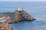
Le cap de Gate, ou Cabo de Gata, est un promontoire montagneux et escarpé. Il porte un phare, tour blanche bâtie sur un ancien château, avec à ses pieds un îlot et quelques rochers. Les 63 km de côte du parc naturel de Cabo de Gata sont un véritable paradis pour les amateurs ...
At approximately 4.5 NM from Cape Gate, the Morro Genoves is a conical hill, with a flat top of 82 m. N of Morro Genovese, is a small bay, Port Genoves, separated from the cove San Jose by a point dominated by the ruined castle of San Jose de Los Genoveses.


 canal 9


 dans la ville


 Ecole de voile
 Le phare de Roquetas
 The large central pier was converted into a marina, many free places in June 2011.
 L'entrée du port est large de 90 m et profonde de4 à 6 m sur fond de boue.