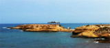
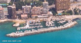
Situated in S Tabarka island and N Benidorm island, the marina El Campello is located below watchtower erected between 1554 and 1557.
El Campello is open to S/SW swell.
T. 965.631.748
F. 965.631.964
475 b. (<15 m) includ. 140 visit.
2012/05/21
Update
Jojo
Au S de l'île de Tabarka et au N de l'île de Benidorm, le port de plaisance de El Campello est situé aux pieds de la tour de guet érigée entre 1554 et 1557.
El Campello est ouvert à la houle S/SW.
T. 965.631.748
F. 965.631.964
475 pl. (<15 m) dont 140 visit.
2012/05/20
Update
Jojo
Share your comments or photos on "Puerto El Campello (C. Valenciana)"
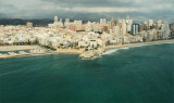
Ensenada de Benidorm lies between Cabezo del Tosal and Punta de la Escaleta, 3 miles E. the small hill Canfali, which forms a promontory in the center of the cove of Benidorm, divides the coast into two splendid sandy beaches, the Levant and the Ponant.
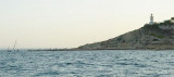
1 NM N of Punta del Rio, N El Campello marina, an old islet (La Illeta islet) is connected at the land by a a roadway. It is dominated by the tower of Illeta.
Algar de la Almadraba, centered about 6 miles NW of Denia, is an extensive area of foul ground which lies off this stretch of coast. This area has depths of 25 to 36m and heavy seas are raised over it by onshore winds.


 Canal 9


")
")
")
 Situated in S Tabarka island and N Benidorm island, the marina El Campello is located below watchtower erected between 1554 and 1557.
 Au S de l'île de Tabarka et au N de l'île de Benidorm, le port de plaisance de El Campello est situé aux pieds de la tour de guet érigée entre 1554 et 1557.