Puerto Bolivar

Puerto Bolivar

To precisely geolocate this site. Update if necessary.

Localisation

Puerto Bolivar
LatitudeLongitude
DMS------
DM------
DD------

Characteristics

Water
First aid
Shipyard
Grocery
Harbour

Description

Small port .
2011/05/15
Update
xavier0ng
Petit port .
2011/05/15
Update
xavier0ng
Puerto Bolivar
2011-05-15
Update
xavier0ng
Share your comments or photos on "Puerto Bolivar"

Sites around Puerto Bolivar

Flying distances - Direct line

Talara

109nm
224°
Port.
14 May 11
futuremark

Bahia De Manta

146nm
342°
Small port protected by a breakwater.
15 May 11
rustlegg

Salaverry Pérou

303nm
168°
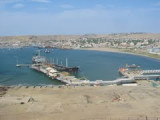
Salaverry, port commercial et de pêche Pas de place à quai qui est réservé aux cargos.Mouillage restreint parmi les barques de pêche et navette au ponton principal par barques-taxi.Avantages et inconvénients liés à la rareté des escales des plaisanciers.Trujillo, ville principale ...
11 Jun 11
jcf

Tumaco bay (Colombia Pacific Coast)

312nm
13°
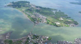
This interesting, friendly town is on the border with Ecuador. It sits on an island connected to the mainland by a causeway. Many of the houses in the area are built on stilts over the water.

Tumaco is a military controlled port. You must call Guardacosta on VHF channel 16 ...
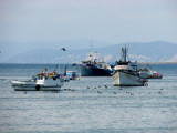
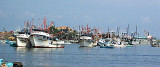
7 Jan 16
Joëlle