Portland Harbour

Portland Harbour

To precisely geolocate this site. Update if necessary.

Localisation

Portland Harbour
LatitudeLongitude
DMS------
DM------
DD------

Characteristics

Water
Fuel
First aid
Shipyard
Grocery
Naval Base

Description

Portland Harbour
2011-08-27
Update
Philippe
Ebook

Manche - English Channel

  • 240 sites
  • 186 photos
  • publication date: 7 Jul 2023
  • .pdf file size: 229 Mb
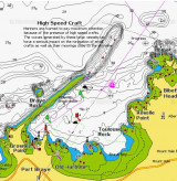
Naval base protected by a breakwater.
2012/05/5
Update
Geof
Base navale protégée par une digue.
2012/05/5
Update
Geof
Share your comments or photos on "Portland Harbour"

Sites around Portland Harbour

Flying distances - Direct line

Lulworth Cove

7.8nm
69°
Safe Natural Harbour on the Jurassic Coast.
21 Apr 11
DD

Christchurch Harbour

27nm
70°
Mainly leisure craft and local fishing boats. Has double high tide.
20 Jun 19
Noddy

Yarmouth

36nm
77°
- Your comments are welcome - If you would like to add your own report on a marina, harbour, beach or anchorage please click on the "Edit" tab above, delete this text and type your comments. Digital photos are also very welcome using the "photo" link in the left menu. - Regards - The Webmaster
9 Nov 07
Anonymous

Alderney Harbour

51nm
169°
The Harbour office is open: June to August: 0800 – 2000; At all other times: 0800 – 1700 Monday to Friday;On arrival please call into the Harbour Office where our friendly and helpful staff will ensure that you have all the nautical, weather and general information required for ...
8 Oct 15
header