Noirmoutier harbor is a small drying harbor. It is formed by the meeting of three canals and is mainly used by fishing boats. Small craft can enter at HW with drafts up to 2.5m at springs and 1m at neaps.
2013/03/14
Update
dd
Port d'échouage qui servait autrefois à l'exportation du sel de Noirmoutier.
Port d'échouage offrant un bon abris au SE de la Pointe du Devin. Il n'est accessible qu'aux navires à faible TE.
Capacité : 850 places dont 3 places visiteurs sur pontons et catways, 30 places par évitage sur corps morts. Tel: 02 51 35 81 26
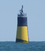
Basse de Martroger, a drying reef, extends 1.1 miles seaward. A light is shown from a tower, 16m high, standing on the N end of this reef, 1.6 miles NE of Pointe de L’Herbaudiere.
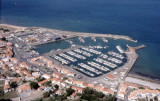
L’Herbaudiere, a small tidal harbor, is situated close E of Pointe de L’Herbaudiere and protected by
breakwaters which form an entrance, 25m wide. A sand bar
lies close N of the entrance.
The harbor is mainly used by fishing boats, which berth in a
basin on the W side, and yachts, ...


 Noirmoutier harbor is a small drying harbor. It is formed by the meeting of three canals and is mainly used by fishing boats. Small craft can enter at HW with drafts up to 2.5m at springs and 1m at neaps.
 Port d'échouage qui servait autrefois à l'exportation du sel de Noirmoutier.