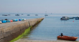
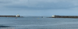
Lesconil, a small drying harbor, lies E of Pointe de Penmarc’h and is protected by breakwaters. It is used by fishing boats and yachts. Karreg Greiz, a shoal with a depth of 4.1m, lies 1.8 miles SSE of the harbor entrance and is marked by a lighted buoy.
2012/07/18
Update
AB
Le port de LESCONIL dispose de 95
mouillages permanents. Il met à la disposition des plaisanciers une trentaine de postes à
quai ou sur bouées réservés à l'escale et/ou cabotage.
Port de plaisance - Bureau du port : 06 72 04 55 80 ou 06 47 82 77 12
C'est un bon abri par vents du Nord-Ouest à Est, mais il reste exposé aux vents de Sud et même par vents d’Ouest et Sud-Ouest.
Iles de Glenan are a large group of islands, islets, and reefs which lie on an extensive bank. Several narrow channels lead between the islands and shoals of Iles de Glenan, but they are only used by small vessels with local knowledge.
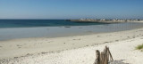
Anse de Lesconil is a fairly exposed reef break that
has quite consistent surf, although summer tends to be mostly flat.
Offshore winds are from the northwest. Waves just as likely from local
windswells as from distant groundswells and the ideal swell angle is
from the west ...
Le Guilvinec is a small fishing port, is located E of Pointe de Penmarc’h. The harbor can be contacted on VHF channel 12. It is protected by breakwaters , has dredged depths of 2.5 to 5m and a small fishing fleet. A large prominent fish market building stands at the W side of the harbor.
This small harbor is located at the W side of the bay. It lies on the S side of the mouth of theRiviere de Pont l’Abbe and is used by pleasure craft and fishing vessels. There are depths of 2 to 4m alongside the quays.Vessels with drafts up to 5m can enter at springs; vessels with ...


 3 rampes


 Lesconil, a small drying harbor, lies E of Pointe de Penmarc’h and is protected by breakwaters. It is used by fishing boats and yachts. Karreg Greiz, a shoal with a depth of 4.1m, lies 1.8 miles SSE of the harbor entrance and is marked by a lighted buoy.
 Le port de LESCONIL dispose de 95
mouillages permanents. Il met à la disposition des plaisanciers une trentaine de postes à
quai ou sur bouées réservés à l'escale et/ou cabotage.
Le port de LESCONIL dispose de 95
mouillages permanents. Il met à la disposition des plaisanciers une trentaine de postes à
quai ou sur bouées réservés à l'escale et/ou cabotage.