Port de Carentec

Port de Carentec

To precisely geolocate this site. Update if necessary.

Localisation

Port de Carentec
LatitudeLongitude
DMS------
DM------
DD------

Characteristics

Mooring buoy

Description

Port d'échouage.
2012/05/16
Update
dd
Port de Carentec
2012-05-16
Update
dd
Ebook

Bretagne Nord

  • 98 sites
  • 69 photos
  • publication date: 8 Jul 2023
  • .pdf file size: 89 Mb
Ebook

Manche - English Channel

  • 240 sites
  • 186 photos
  • publication date: 7 Jul 2023
  • .pdf file size: 229 Mb
Share your comments or photos on "Port de Carentec"

Sites around Port de Carentec

Flying distances - Direct line

Île de Batz

5.5nm
325°
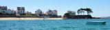
Ile de Batz, a low island, is separated from the mainland by a foul channel. The island is radar conspicuous and a conspicuous signal station stands on an old fort at its center.
The main attraction is its exotic garden, some lovely beaches and great views from the top ...
15 May 12
dd

Port de Pempoul

1.6nm
292°
Mouillage sur corps morts de 200 bateaux.
Capitainerie
- Tel: 02.98.62.86.49.
- port.pempoul@orange.fr
15 May 12
dd

Anse de Térénez

2.9nm
88°
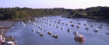
Port communal (150 places) sur corps-morts. Stockage des annexes (100 places).
Mouillage à échouage, par un coefficient de 60, accessible environ 2h avant et après la pleine mer
Eloignement des commerces et services (Plougasnou : 5,3 km).
16 Jul 12
AB