Port San-Peire (Les Issambres)

Port San-Peire (Les Issambres)

To precisely geolocate this site. Update if necessary.

Localisation

Port San-Peire (Les Issambres)
LatitudeLongitude
DMS------
DM------
DD------

Characteristics

Port
VHF canal 9
Water
Phone
Electricity
Fuel
Shipyard
Shower
WC
Restaurant

Description

Port well sheltered from all winds.
Danger: precautions to be taken in Mistral and winds SE.
  • 440 B. incl. 5 visit. (< or = 12m)
2010/05/26
Update
so long
Port bien abrité de tous les vents.
Danger: précaution par Mistral, vent SE.
  • T. 04 94 49 40 29
  • F. 04 94 96 90 58
  • 440 pl. dont 5 visit.(< ou = 12m)
2010/05/26
Update
so long
Port San-Peire (Les Issambres)
2010:05:24 10:37:46
2010-05-26
Update
Anonymous
Ebook

Côte d'Azur - French Riviera

  • 309 sites
  • 647 photos
  • publication date: 6 Jul 2023
  • .pdf file size: 252 Mb
Share your comments or photos on "Port San-Peire (Les Issambres)"

Sites around Port San-Peire (Les Issambres)

Flying distances - Direct line

Baie de Cannes

18nm
51°
Cannes bay is located between Pointe de l'Aiguille and Cap de la Croisette, 4 miles ENE, from which the islands "Les Îles de Lerins"  extends up to 2 miles. The E side of the gulf is occupied by the town and port of Cannes well known by it's film festival, where the houses form ...
4 Jul 12
Atx

Île du Levant

20nm
206°
Prohibited areas, the limits of which are shown on the chart, lie SW of Pointe du Titan (Ile du Levant) and extend up to 2 miles from the coast. These areas, which are used by French naval vessels, are not in force between July 1 and August 31.
Vessels are prohibited from approaching ...
10 Jul 11
Atb

Baie de Bougnon

0.1nm
242°
This bay is bordered by numerous villas, and a large white building, which is very prominent from seaward, stands on its N shore.
The bay offers shelter from NW winds, but the anchorage is untenable with winds from seaward.
Vessels may anchor to seek shelter from the Mistral, ...
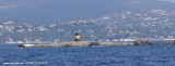
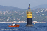
16 Jul 11
Agien

Les Sardinaux

1.4nm
176°
Cardinale Est à 900m à l'est de la Pointe des Sardinaux. Au sud ouest se trouve  la Sèche à l'huile.
9 Aug 15
Atb

La Sèche à l'Huile

1.7nm
180°
Seche à l’Huile, a shoal, lies at the SE extremity of a bank. It has a least depth of 3m and is marked by a prominent lighted beacon.
9 Aug 15
Atb