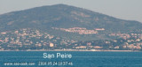
This bay is bordered by numerous villas, and a large white building, which is very prominent from seaward, stands on its N shore. The bay offers shelter from NW winds, but the anchorage is untenable with winds from seaward. Vessels may anchor to seek shelter from the Mistral, in 4 to 8m, opposite the beaches that line the bay SW of Port San-Peire-Les Issambres.
2011/07/16
Update
Agien
Mouillage par 8 m d'eau au SW du port pour se protéger du mistral.
Prohibited areas, the limits of which are shown on the chart, lie SW of Pointe du Titan (Ile du Levant) and extend up to 2 miles from the coast. These areas, which are used by French naval vessels, are not in force between July 1 and August 31. Vessels are prohibited from approaching ...
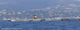
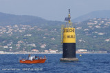
La pointe des Sardinaux, à l'entrée du golfe de St Tropez, est une avancée basse, rocheuse où la mer peut briser dangereusement. Deux tourelles S et E balisent les roches affleurantes de la Sèche à l'Huile et des Sardinaux qui débordent de 900m la pointe N à l'entrée du ...


 This bay is bordered by numerous villas, and a large white building, which is very prominent from seaward, stands on its N shore.
 Mouillage par 8 m d'eau au SW du port pour se protéger du mistral.