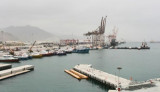
Port of Fujairah (or Fujayrah) is the only multi-purpose port on the Eastern seaboard
of the United Arab Emirates, approximatly 70 natuticak miles from the
Straits of Hormuz. Initial Construction of the Port started in 1978 as
part of the economic development of the UAE. Full ...
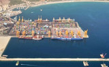
Khor Fakkan (or Khawr Fakkan) is a town located along the Gulf of Oman on the east coast of the United Arab Emirates (UAE). The town is set on the picturesque bay of Khor Fakkan, which means "Creek of Two Jaws". Khor Fakkan belongs to the emirate of Sharjah but is geographically ...
Saadiyat Island is a large, low lying island of 27 km², 500 metres off the coast of Abu Dhabi island to be developed. Saadiyat Island’s Cultural District will house the world’s largest single concentration of premier cultural assets, including the Lord Norman Foster-designed ...
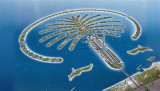
Palm Jebel Ali is located near Jebel Ali port. It is the most eccentric of the three islands at 50 km from downtown Dubai.With 17 palms, it will host marinas, Sea Village (themed amusement park and aquatic), residences ...


 Port protected by a breakwater.
 Port protégé par une digue.