Ile de Porquerolles lies centered 3 miles SE of Ponte de l’Esterel. The summit of the island, located 1 mile from its E end, is 142m high and surmounted by a signal station.
Prohibited areas, the limits of which are shown on the chart, lie SW of Pointe du Titan (Ile du Levant) and extend up to 2 miles from the coast. These areas, which are used by French naval vessels, are not in force between July 1 and August 31. Vessels are prohibited from approaching ...
Toulon is a large military harbour on the Mediterranean coast, with a major French naval base.The prevailing winds are from the NW (Mistral) and W. These winds may reach a velocity of Force 11. Winds from the E and SE, which are less frequent, are generally accompanied by rain squalls, ...
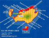
Ile de Port Cros, lies close E of Ile de Bagaud, is mainly wooded and is the highest island of the chain. Its summit, 207m high, is surmounted by a building, with two white cupolas, which are visible from a considerable distance. An islet, 63m high, lie 0.2 mile S of the S extremity ...
Golfe de Giens is entered between Pointe de Carqueiranne and Pointe Escampobariou, 4.7 miles SE. Pointe Escampobariou is the SW extremity of Presqu’ile de Giens, a peninsula, the W side of which is 118m high and surmounted by a tower. The E side of this gulf is bordered by ...
Le Lavandou is protected by a jetty and a mole, and has depths of 1 to 4m.The original basin is used by small craft. Anchoring is prohibited within this basin on account of mooring chains lying on the bottom. Quays at the W ends of the mole and the breakwater are reserved ...


 Baie bien abritée du vent d'est et du mistral.