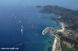
Le Lavandou is protected by a jetty and a mole, and has depths of 1 to 4m.The original basin is used by small craft. Anchoring is prohibited within this basin on account of mooring chains lying on the bottom. Quays at the W ends of the mole and the breakwater are reserved for the use of local ferries. An extensive yacht basin, protected by a curved breakwater, lies close SE of the original basin. Anchorage may be obtained, in depths of 15 to 20m, muddy sand, good holding ground, about 0.2 mile SE of the harbor.
1050 berths in 3 basins (<30m) of which 100 visit.
2012/03/24
Update
dd
Capitainerie
2015:09:27 11:42:15
2015-09-28
Update
Le port de plaisance du Lavandou est situé au fond de la rade de Bormes à 7 M au N de Port-Cros.
Ile de Porquerolles lies centered 3 miles SE of Ponte de l’Esterel. The summit of the island, located 1 mile from its E end, is 142m high and surmounted by a signal station.
Prohibited areas, the limits of which are shown on the chart, lie SW of Pointe du Titan (Ile du Levant) and extend up to 2 miles from the coast. These areas, which are used by French naval vessels, are not in force between July 1 and August 31. Vessels are prohibited from approaching ...
Toulon is a large military harbour on the Mediterranean coast, with a major French naval base.The prevailing winds are from the NW (Mistral) and W. These winds may reach a velocity of Force 11. Winds from the E and SE, which are less frequent, are generally accompanied by rain squalls, ...
Golfe de Giens is entered between Pointe de Carqueiranne and Pointe Escampobariou, 4.7 miles SE. Pointe Escampobariou is the SW extremity of Presqu’ile de Giens, a peninsula, the W side of which is 118m high and surmounted by a tower. The E side of this gulf is bordered by ...
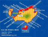
Ile de Port Cros, lies close E of Ile de Bagaud, is mainly wooded and is the highest island of the chain. Its summit, 207m high, is surmounted by a building, with two white cupolas, which are visible from a considerable distance. An islet, 63m high, lie 0.2 mile S of the S extremity ...
This marina is located NW in one of the most attractive bays on the coast opposite the islands, between cap Benat and cap Negre. The main sea wall goes round the peninsula, the position of the jetty and the break-water providing good shelter. 950B. incl. 80 visit.


 canal 9


 Le Lavandou is protected by a jetty and a mole, and has depths of 1 to 4m.The original basin is used by small craft. Anchoring is prohibited within this basin on account of mooring chains lying on the bottom.
 Capitainerie
 Le port de plaisance du Lavandou est situé au fond de la rade de Bormes à 7 M au N de Port-Cros.