Plage Vilin Izella

Plage Vilin Izella

To precisely geolocate this site. Update if necessary.

Localisation

Plage Vilin Izella
LatitudeLongitude
DMS------
DM------
DD------

Characteristics

Mooring buoy

Description

Plage Vilin Izella
2012-05-16
Update
dd
Ebook

Bretagne Nord

  • 98 sites
  • 69 photos
  • publication date: 8 Jul 2023
  • .pdf file size: 89 Mb
Share your comments or photos on "Plage Vilin Izella"

Sites around Plage Vilin Izella

Flying distances - Direct line

Archipel des Sept-îles

14nm
41°
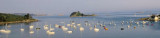
Jentilez or Sept Îles (French for seven islands) is a small archipelago off the north coast of Brittany, in the Perros-Guirec commune of Côtes-d'Armor. This group of islands is home to an important bird reserve, and is the home of various seabirds, including Northern Gannets, Cormorants, ...
19 May 12
dd

Île de Batz

11nm
283°
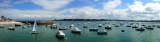
Ile de Batz, a low island, is separated from the mainland by a foul channel. The island is radar conspicuous and a conspicuous signal station stands on an old fort at its center.
The main attraction is its exotic garden, some lovely beaches and great views from the top ...
15 May 12
dd

Locquirec

2.8nm
105°
Bouées pleine eau : 26 (dont 2 visiteurs) Bouées échouage : 304 (dont 5 visiteurs)
17 May 12
dd

Primel Le Diben

4.3nm
273°
Bouées échouage : 343 (dont 3 visiteurs)
Places visiteurs : 15
16 May 12
dd

Anse de Térénez

5.5nm
252°
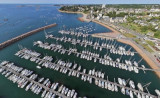
Port communal (150 places) sur corps-morts. Stockage des annexes (100 places).
Mouillage à échouage, par un coefficient de 60, accessible environ 2h avant et après la pleine mer
Eloignement des commerces et services (Plougasnou : 5,3 km).
16 Jul 12
AB

Trébeurden

6.5nm
51°
Trébeurden Marina is located in the bay of Lannion, protected from the strong gales coming from the west by the Milliau Island.
17 May 12
dd