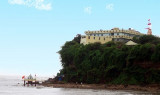

Jafarabad harbour (W India)
11nm
236°
Jafarabad is a walled town, with several round towers, on the highest ofwhich ...
29 Feb 12
Jojo
| Latitude | Longitude | |
| DMS | --- | --- |
| DM | --- | --- |
| DD | --- | --- |
 channel 16, 71
 Pipavav Bandar, the principal port for Dongar, about 6 miles N, is the principal town on this part of the coast.
Pipavav Bandar lies on the NW shore of the West Channel. It is an all season port offering container, bulk, break bulk and liquid cargo handling services. It imports and exports bulk cargo including coal, cement and fertilizer, break bulk, and LPG.
Chanch Island, the W extremity of which is located about 2.3 miles NNE of Shival Island, fronts the coast for about 4.5 miles. There is an extensive mangrove swamp close inland, which is submerged only at very high spring tides A heavy swell occurs during the Southwest Monsoon.
The mean spring tidal range is about 2.7m. The mean neap tidal range is only 1.2m.
The ebb current, which sets SW from S of Chanch Island, divides N of Bhensla Rock. One branch sets W through East Channel and then SW through West Channel, attaining a velocity of 2 knots at springs and 1 knot at neaps. The other branch sets toward Savai Bet Reef and then W along the coast at a velocity of 2 to 2.5 knots at springs and 1.5 knots at neaps.
The flood current sets across the S approach to West Channel and there divides. One branch sets N through the channel and then NE toward Chanch Island at a velocity of 1.5 to 2.5 knots at springs and about 1 knot at neaps. The other branch sets ENE past Savai Bet Reef, and then toward Bhensla Rock at a velocity of 3 knots at springs and 2 to 3 knots at neaps.
Strong eddies form in West Channel at HW and LW.
Pipavav Port is approached from the S through West Channel, about 0.75 mile long, dredged to about 14.5m, and marked by lighted buoys. West Channel is the recommended route to Pipavav Port and anchorage due to much shallower depths in the East Channel. East Channel, leading N of Bhensala Rock and Shiyal Bet, should only be used by light-draft vessels with local knowledge, and only at high water.
West Channel leads W of Shiyal Bet NNE from a position about 0.3 mile E of the W beacon for about 0.2 mile, then NE to a position between the N end of the GPPL Jetty and Lighted Buoy No. 9 light, where there is a turning basin with a radius 275m and a depth of 13.5m. West Channel can be used at any time day or night. The channel width varies from 380m at its beginning and widens to 575m in the vicinity of the GPPL Jetty before narrowing to a width of 200m in the vicinity of the N end of the LPG Jetty.
The GPPL Jetty, consisting of four berths, has three berths in line for container operations which can accommodate vessels up to 305m in length and has a dredged depth of 14m alongside.
The fourth berth extends 47m into the channel from the in-line berths and will accommodate container, bulk, and general cargo vvessels up to 240m in length with a maximum draft of 13m.
Close N of the GPPL Jetty is the LPG Berth with a jetty length of 337m able to accomodate vessels up to 15.5m of draft.
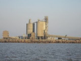
The UCL Jetty serves a cement factory on the W side of the entrance channel, about 1 mile ESE of Chachuda Temple. The jetty is 337m in length, L-shaped, with a berth able to accommodate vessels up to 200m in length and draft up to 10.5m on arrival and 11m on departure. This jetty does not operate between June 16 and August 14.
Only small vessels with local knowledge can proceed to Pipavav Bandar, as there is only a depth of 2.1m in the channel leading to it.
The shores of the islet are composed of rocky cliffs, 10.4 to 16.5m high, with the exception of the NE side and the shore of a small bay on its NW side, which are low and sandy. Remains of old fortifications are on the N and E sides of the islet. The greater part of the islet is covered with ruins of what must have been extensive buildings and temples.
Savai Bet Reef, a drying reef, steep-to on its E edge, extends about 0.4 mile E from Savai Bet.
Bhensla Rock, a bluff rocky islet, 15m high and nearly steepto on its E side, is located 1 mile ENE of Savai Bet.
Montapat Creek, separating the NW and N sides of Chanch Island from the mainland, is the outlet for waters that cover an immense tract of marshy land at high water.
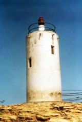
A circular tower, 9m high, is conspicuous at the W edge of a reef extending about 0.3 mile WSW from the W extremity of Chanch Island.
One Tree Hill, at the W extremity of Chanch Island, is 14m high.
Spit Sand, which dries 0.3m, extends nearly 1.8 miles SW from the SW edge of the above-mentioned reef. The SW edge of Spit Sand is called The Spit and has a least depth of 1.9m.
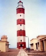
A palace, 26m high, about 2 miles ENE of the circular tower, is a good landmark from the SE and S.
Beacons on the mainland, in line bearing 019°, and about 2 miles N of Shiyal Bet, lead through West Channel. Beacons stand on drying reefs on each side of the entrance to West Channel.
Chachuda Temple, 24m high, is conspicuous on the mainland, about 1.5 miles WSW of Shiyal Bet.
Pilotage is compulsory and available at all times.
Vessels should send their ETA 72 hours, 48 hours, 24, hours, and 12 hours, in advance to the harbormaster. Vessels should call Port Control on VHF channel 16 or 71 for pilot boarding information. The use of tugs is compulsory and the pilot boards from a harbor tug in position 20°52.5'N, 71°29.8'E.
Vessels should enter West Channel with the beacons on the mainland in line bearing 019° and steer in on this bearing until Chachuda Temple bears 275°, when course can be shaped to the anchorage.
Due to the strong current setting across the West Channel entrance, Pipavav Harbormaster recommends for vessels to maintain a speed over ground of 3-4 knots.
A ferry service operates between the SW part of the GPPL Jetty and NW Shiyal Bet.
")
Ebook | Arabian Sea
|