Phare du Prêcheur

Phare du Prêcheur

To precisely geolocate this site. Update if necessary.

Localisation

Phare du Prêcheur
LatitudeLongitude
DMS------
DM------
DD------

Characteristics

Lighthouse

Description

Phare classé monument historique construit en 1927.
2020/02/9
Update
Ebook

Antilles - West Indies

  • 375 sites
  • 704 photos
  • publication date: 9 Jul 2023
  • .pdf file size: 141 Mb
Phare du Prêcheur
2020-06-12
Update
Anonymous
Share your comments or photos on "Phare du Prêcheur"

Sites around Phare du Prêcheur

Flying distances - Direct line

Anse Céron

1.9nm
Située au nord du bourg du Prêcheur et non loin de l'Habitation Céron dans le Nord Caraïbe, cette plage est exceptionnelle. L'Anse Céron est un lieu sauvage. Cependant, sous les zones ombragées par les cocotiers et les raisiniers, des douches ainsi que quelques tables de pique-nique ...
11 Feb 20

Îlet La Perle

2.3nm
357°
Nice diving spot where you can see a lot of fishes. Be carreful with the current.
9 Feb 20

Anse Couleuvre

2.4nm
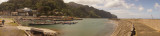
Black sand cove in the North West of Martinique. Easily accessible by sea, much more difficult by land. The road which goes up along the NW coast of Martinique ends here by a little passable road.
9 Feb 20

St.Pierre (Martinique)

4.3nm
140°
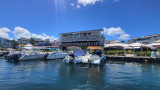
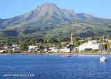
Access to the anchorage does not present any particular difficulties. Beware, however, of the many fishing traps.
In Saint-Pierre you can visit many vestiges linked to its tragic past. The eruption of 1902 destroyed dozens of ships whose underwater wrecks can today be observed ...
9 Feb 20

Grand'Rivière

4.9nm
30°
At the end of the North-East road, Grand'Rivière has a port mainly dedicated to fishing.
Good restaurant "Tante Arlette" in the village.
9 Feb 20

Houlographe Basse Pointe

8.3nm
50°
Houlographe de Basse Pointe fournissant des mesures en temps réel de la houle.
Extrait du site http://candhis.cetmef.developpement-durable.gouv.fr/
Meteo
18 Jan 16
anonymous