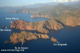
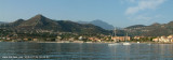
Crique de Branca, à lOuest du port de l'île Rousse, sous le phare offrant un bon mouillage (15m de fond) par vent de secteur E et Nord-Est. Par Libeccio la protection est nulle. En arrière plan les car-ferries de l'autre coté de la presqu'île. Sur la gauche la tour génoise du XVème siècle. 2006-07-18 Bearing:90°
Le phare de la Pietra date de 1857, une tour génoise du XVème siècle se dresse à proximité. Le sémaphore de l'île Rousse se trouve à 139m d'altitude, il est classé 1ère catégorie.
2012/05/8
Update
Jojo
Le phare de La Pietra
2004:07:26 06:35:28
2012-05-08
Update
Jojo
La tour génoise
2004:07:26 06:36:45
2012-05-08
Update
Jojo
Le sémaphore
2004:07:26 06:43:16
2012-05-08
Update
Jojo
Share your comments or photos on "Phare Ile Rousse"
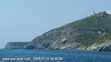
Capo Sagro is located at 11 NM. S Finocchiarola islands. He has a signal station and a semaphore rises N of it. Mount Merizatodio, 778 m high, is 1.5 MN to W Cape and dominates the immediate area.
The village of Erbalunga, situated 1.5 miles SSW of Capo Sagro, stands on the S ...
The nature reserve, which is part of the Regional Natural Park of Corsica, occupies the Scandola peninsula, an impressive, porphyritic rock mass. The vegetation is an outstanding example of scrubland. Seagulls, cormorants and sea eagles can be found there. The clear waters, with their ...
Iles Rousses, a group of four yellowish islands, lies close off the coast, in the vicinity of the town of L’Ile Rousse. Grande Ile Rousse (Isula la Pietra), the largest island, is connected by a causeway to Ile Sicota, the S island of the group, which in turn is connected by another ...
Giunchetu or Giuncheto or Ghjunchetu is an anchorage of good weather, S from L'île Rousse. Vignola bay, his neighbor, is also a enjoyable bay by good weather. Caution around.
For lovers of sub-marine life, the rocks between the beaches of Giunchetu and Bodri ...
The small bay of Fornello, in Balagne ((Not to be confused with the cove of Fornello in the SW coast of Corsica), is located just S of the Marine Davia, before "Punta di Varcale".
You can anchor by 3/4 m, in good weather, in front of the beautiful sandy beach.
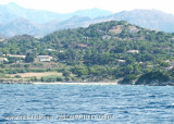
This first beach after Ile Rousse, just east of a Genoese tower, offers no shelter from sea winds. However, it is very crowded in good weather as the road passes nearby and a large holiday village was built just to the east.


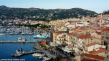


 Crique de Branca, à lOuest du port de l'île Rousse, sous le phare offrant un bon mouillage (15m de fond) par vent de secteur E et Nord-Est. Par Libeccio la protection est nulle. En arrière plan les car-ferries de l'autre coté de la presqu'île.
 Le phare de la Pietra date de 1857, une tour génoise du XVème siècle se dresse à proximité.
 Le phare de La Pietra
 La tour génoise
 Le sémaphore