Penerf

Penerf

To precisely geolocate this site. Update if necessary.

Localisation

Penerf
LatitudeLongitude
DMS------
DM------
DD------

Characteristics

Port
Slip

Description

Penerf
2013-01-05
Update
dd
Ebook

Golfe de Gascogne

  • 266 sites
  • 250 photos
  • publication date: 9 Jul 2023
  • .pdf file size: 204 Mb
Mise à l'eau, à toute heure.

La rivière de Pénerf  est  un haut lieu de l'ostréiculture.

2013/03/4
Update
dd
Share your comments or photos on "Penerf"

Sites around Penerf

Flying distances - Direct line

Île Dumet

6.1nm
179°
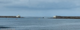
 This low and barren island is a bird sanctuary. A light is shown from a structure, 6m high, standing on an old square fort near the E end of the island. Another old fort stands on the N extremity of the island.
2 Dec 07

Ile aux Moines

9.9nm
295°
Provide here details of the site. You can put text or images.
19 Sep 10

Anse de Suscinio

4.1nm
258°
Mouillage  le long d’une belle plage  bien abrité du secteur N et et de l' W si on se rapproche de la pointe de Beg Lan. Attention aux roches.
8 Jan 13
dd

Lasné

5.2nm
305°
1 Jan 70
Anonymous

Ile Tascon

5.9nm
311°
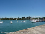
The Tascon island is situated in Morbihan golf. The access can be done by a road two hours before and after the low tide. There are 3 permanent residant during the year but the island is more touristic during the summer. 
19 Sep 10

Sémaphore de Piriac

8.7nm
161°

Missions particulières : Plaisance entre la baie de Quiberon et la pointe du Croisic.
24 Nov 07