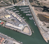
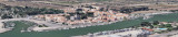
Port de Narbonne-Plage, an extensive yacht harbor, is situated 4 miles NE of Gruissan-Plage and is protected by two breakwaters. A rectangular prohibited area lies 3 miles E of the harbor entrance.
Rocher St. Pierre located close NE of Port de Narbonne-Plage, is 5m high and surmounted by the sand-covered ruins of a battery. It is the most distinctive mark in this vicinity. A prohibited area, marked by lighted buoys, lies E of Rocher St. Pierre. A conspicuous radar tower, 25m high, stands 3.2 miles W of Rocher St. Pierre and is surmounted by a dark green dome. A water tower stands 0.5 mile WSW of Rocher St. Pierre and also is conspicuous.
2012/04/28
Update
Atb
2007:07:27 16:27:53
2012-04-28
Update
Atb
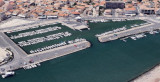
Accès du port difficile par vent ou houle d'Est. Port:
Port de plaisance
qui se situe à un mille de l'embouchure de l'Aude, rive gauche en remontant. Possibilité de mettre les bateaux sur la rive ou bien dans les 2 bassins du port. Le port est équipé de 230 anneaux à l'année et de 80 en saison (de juin à septembre). Ouverture ...
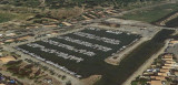
Extensive yacht harbor, is situated 3.5 miles NNE of Grau de la Vieille Nouvelle and is protected by two moles, A prohibited area, the limits of which are marked by buoys, lies centered 1.5 miles SE of the harbor entrance. A submarine pipeline extends 2 miles ESE from a point ...
Valras-Plage, a resort, is situated at the mouth of the River Orb, 6.5 miles NE of Rocher St. Pierre. A yacht and fishing craft harbor is situated within the river mouth. A casino and a large water tower stand in this vicinity and are excellent landmarks from seaward.


 VHF 9
VHF 9

 Station service à 300m de la Capitainerie
 3.5t
3.5t


 Port de Narbonne-Plage, an extensive yacht harbor, is situated 4 miles NE of Gruissan-Plage and is protected by two breakwaters. A rectangular prohibited area lies 3 miles E of the harbor entrance.
 Accès du port difficile par vent ou houle d'Est.