The harbour of Menton Garavan is protected from wind and waves, from all directions for boat up to 40 m long. The border between France and Italy lies about 1 mile E of Port de Menton-Garavan in the vicinity of Ruisseau Saint- Louis. It is indicated to seaward by the alignment of two beacons. The front beacon stands on the beach and the rear beacon stands close W of a bridge which spans the river.
2012/04/26
Update
chx
Bien abrité de tous les vents.
Tél : 04.93.28.78.00
Fax : 04.93.35.48.01
email : accueil@portdementongaravan.com
site web : http://portdementongaravan.comen cours de construction
800 Places dont 176 pour visiteurs (longueur maxi 40 m)
Jetées extérieures - 3 m
Avant-port - 4,5 m
Bassins - 2 à 4,5 m
Amarrages sur chaines et pendilles
2007/12/16
Update
Share your comments or photos on "Menton - Garavan"
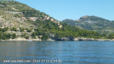
Le Cap d'Ail marque la séparation entre les baies de Beaulieu et de Monaco. Les abords étant malsains, il faut s'en écarter assez largement. Le cap Martin est couvert de pins d'où émerge un sémaphore blanc sur les hauteurs.
Mento is a small harbor, lies 2 miles NE of Cap Martin. It is protected by two jetties and is used by fishing boats and yachts. The town stands in an amphitheater which is situated on a small promontory at the NE end of a beach. A square tower stands on the extremity of the promontory, ...
The Presqu'ile de Saint Hospice , 40m high, forms a peninsula which extends E from the center of the E side of the Cap Ferrat promontory. It is surmounted by a chapel and a conspicuous tower Pointe Saint Hospice, located 1.2 miles NE of the Cap Ferrat Light, is the E extremity of ...
Mouillage par 3 à 5 mètres d'eau dans du sable et des herbiers. Aucune protection de la houle. Néanmoins, semble plus accueillant que le mouillage Ouest du Cap Mortolla.


 canal 9


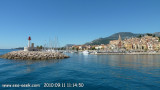
 Vaste port à la frontière entre la France et l'Italie.
 The harbour of Menton Garavan is protected from wind and waves, from all directions for boat up to 40 m long. The border between France and Italy lies about 1 mile E of Port de Menton-Garavan in the vicinity of Ruisseau Saint- Louis. It is indicated to seaward by the alignment of two beacons. The front beacon stands on the beach and the rear beacon stands close W of a bridge which spans the river.
 Bien abrité de tous les vents.