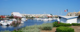
Port Marseillan Plage, a small harbor, lies 2 miles NNE of Port Ambonne and is protected by two jetties. A canal, with a depth of 2m, connects the harbor with Etang de Thau, a lagoon.
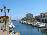
Le Port du Bateau d'Argent est situé à Marseillan-Plage, dans l'Hérault, sur la Route Nationale 112
reliant Cap d'Agde (4 Kms) à Sète (15 Kms).
Les mises à flot s'effectuent directement sur le Canal reliant l'Etang de Thau (400m) à la Méditerranée ( 300m).Port à ...
Au coeur du village naturiste, 300 places aménagées pour accueillir des bateaux de 4 m à 10 m . Accès difficile par E/SE. Port dragué à 1 m. Zone technique avec chantier. Station d'avitaillement en carburants. Cale de halage.
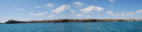
Cap d’Agde , low and rocky, is located 9.5 miles ENE of Valras-Plage. Montagne du Gros Frere, 848m high, stands 29 miles N of the cape and may be sighted on a clear day from a considerable distance to the S. Mont d’Agde, 115m high, stands 1.5 miles NNW of the cape. It is isolated ...
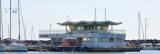
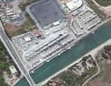
The port located near the cape is accessible via a beaconed channel. Be carreful by strong E/SE winds. It offers more than 3000 berths and all the facilities you need in a large marina.
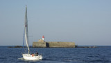
Ilot Brescou, formed by a flat rock, lies 1 mile SW of Cap d’Agde and is surmounted by the grey structure of Fort Brescou. A light is shown from a structure, 11m high, standing at the S corner of the fort. This islet is surrounded by dangers and foul ground.


 Port Marseillan Plage, a small harbor, lies 2 miles NNE of Port Ambonne and is protected by two jetties. A canal, with a depth of 2m, connects the harbor with Etang de Thau, a lagoon.