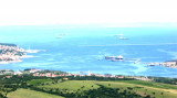
Koper is the unique harbour of Slovenia and is situated at the head of Koprski Bay. The city of Koper (once known as Capodistria) is located on the southeast coast of Koprski Bay. The city of Trieste, Italy is located approximately 6 nmi (11 km) north of Koper.
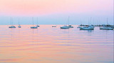
The Marina is located north of the old city.
T. +386 5 66 56 100
F. +386 5 639 5020
Mail: info@marina-koper.si
70 pl. (<15 m) for offshore mooring
30 pl. for boats to dock (<18 m)
2011/08/26
Update
Jojo
2011:08:05 20:11:24
2011-08-26
Update
Jojo
Koper (Capodistria en italien, Kopar en croate, Gafers en allemand), est une ville de Slovénie sur la côte istrienne, de 25 000 habitants. C'est une ville bilingue slovène/italien.
C'est aussi l'unique port de commerce de la Slovénie. Il est situé à l'entrée de Koprski bay, dans la partie la plus au N de la mer Adriatique.
La marina se trouve au nord de la vieille ville. Quelques emplacements, un travel-lift pour sortir les bateaux. Mécaniciens sur le port.
Koperski Zaliv (Baia di Capodistria) is entered between Rt Ronco and Rt Debeli, 5 miles NE.The NE and SW shores of the bay are hilly, but the shore at the head of the bay, through which the Fiume Risano flows, is low. Monte Sermino, surrounded by salt beds, rises isolated in the river ...
The Gulf of Piran or Piran Bay (Slovene: Piranski zaliv, Croatian: Piranski zaljev or Savudrijska vala, Italian: Baia di Pirano) is located in the northern part of the Adriatic Sea, and is a part of the Gulf of Trieste. It is between Rt Madona at N and Rt Saudrija. It was named ...
Limski Kana is entered between Rt Kriz, located 2.4 miles NW of Rovinj, and Rt Sjole, 1 mile NNW. The Lim bay and valley is a peculiar geographic feature found near Rovinj and Vrsar on the western coast of Istria, south of Porec, Croatia.The Lim valley is the 35 km long valley ...
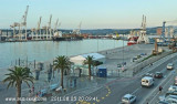
Port S of Marina Koper, W of the old city is the commercial port of trade Slovenian closest to Italy.Dangers: shoal along the shore on either side of Koper, stand therefore at least 0.3 M from the shore.Access: Several lateral buoys with lights signal the deep water channel of the ...


 canal 17


 à 200 m
 Koper is the unique harbour of Slovenia and is situated at the head of Koprski Bay. The city of Koper (once known as Capodistria) is located on the southeast coast of Koprski Bay. The city of Trieste, Italy is located approximately 6 nmi (11 km) north of Koper.
")
 Koper (Capodistria en italien, Kopar en croate, Gafers en allemand), est une ville de Slovénie sur la côte istrienne, de 25 000 habitants. C'est une ville bilingue slovène/italien.
")
")
") Restaurant de la marina
Restaurant de la marina")