Suvali Point (E Cumbay - W India)
6.4nm
254°
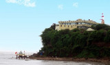
Tapti Light is shown from a white circular stone column, 27m high, on the point; a tomb lies close SE of the light structure.
The coast ...
1 Mar 12
Jojo
| Latitude | Longitude | |
| DMS | --- | --- |
| DM | --- | --- |
| DD | --- | --- |
 channel 67, 9, 16

 Magdalla, an official point of entry, includes the Hazira port complex comprised an Hazira Offshore Terminal, the Hazira LNG Terminal, and a bulk/container terminal presently under construction.
The flood tide sets N, continuing for 1 hour after the time of local HW. The tide often falls 2m just before the commencement of ebb tide.
The Tapi River bar is dry at LW while the entrance and river itself contains many sand banks that are also dry at tides less than HW. Magdalla is approached through a buoyed channel marked 80m wide and dredged to a depth of only 3m.
Pilots are not compulsory but any attempt to locate the entrance to the navigable channel should only be carried out through use of a local pilot.
Anchoring, best seen on the chart, is available in Surat Roads, SW of Hazira Point, in depths from 10m to 12m, but care must be taken due to the strong tidal currents, especially on ebb tide.
Hazira Offshore Terminal (21°09'N., 72°34'E.) is situated about 9 miles NNW of the Tapi River Fairway lighted Buoy. The terminal is an SPM (named Reliance) and is approached through Sutherland Channel.
Tides—Currents: Tidal currents set N and S in the channel at rates of up to 6 knots at springs. The tidal range is reported to be about 7m.
Depths—Limitations: There is a depth of 25m at the SPM. Vessels between 15,000 and 50,000 dwt and up to 250m in length, with a maximum arrival draft of 13m, can be accommodated.
Pilots: Pilots should be requested via the agent. The pilot boards 3 miles S of the SPM. Vessels are berthed only during daylight hours during slack water; a tug is available to assist.
Regulations: Vessels should send their ETA, via the agent, 72 hours, 48 hours, 12 hours, and 6 hours prior to arrival.
Signals: The terminal can be contacted 24 hours, as follows:
1. VHF: VHF channel 67
2. Telephone: 91-261-3035484
3. Facsimile: 91-261-3035489
4. E-mail: shippingradioroom@ril.com
Caution: Anchoring and fishing are prohibited within 1 mile of the SPM and as well as within 0.25 mile of the pipeline extending from the coast to the SPM. A fog signal is sounded from the SPM ; the SPM also includes a radar reflector.
Hazira LNG Terminal (21°06'N., 72°37'E.) is located on the W side of the Hazira peninsula and is approached through the S part of Sutherland Channel.
Tides—Currents: Tidal currents attain a rate of at least 4.5 knots at springs.
Depths—Limitations: The harbor, open WSW, is protected by breakwaters. The entrance channel is 0.65 mile long; it is 0.37 mile wide at seaside, tapers to a width of 0.25 mile wide at the breakwaters, and is dredged to a depth of 13m.
The facility can accommodate an LNG carrier of 145,000m3, with a maximum length of 295m, a maximum beam of 50m, and a maximum draft of 11.5m. The berth, on the N side of the harbor, has an alongside depth of 13m, is oriented in a NE/SW direction, and consists of four breasting dolphins and five mooring dolphins.
Aspect: Range lights, in line bearing 070°, lead through the entrance channel. The seaward end of the entrance channel is marked by a pair of lighted buoys.
Pilots: Pilots are compulsory and board in vicinity of the General Lighterage Area in position 20°57'N, 72°35'E.
Regulations: Vessels bound for the terminal must report to Magdalla Port Control when 2 miles S of Magdalla Port Limits.
All LNG carriers must obtain passage approval from Magdalla Port Control prior to entering the entrance corridor.
Only one vessel at a time is allowed to be underway in the approach corridor. The use of tugs is compulsory; four tugs secure to the LNG carrier prior to entering the dredged entrance channel.
Signals: Magdalla Port Control/VTMS can be contacted, 24 hours, as follows:
1. VHF: VHF channels 9 and 16
2. Telephone: 91-261-2721700
3. Facsimile: 91-261-2721700
Magdalla Port Authority can be contacted, as follows:
1. Telephone: 91-261-2470533
2. Facsimile: 91-261-2475645
3. Telegraph: PORTAL MAGDALLA
4. E-mail: gmbpomin_adl@sancharnet.in
Anchorage: Anchoring is prohibited within the Magdalla Port Limits, which are best seen on the chart, except in an emergency. See paragraph 2.10 for anchoring information.
Caution: The N end of Malacca Banks should not be approached with an ebb tide, because, being nearly steep-to, soundings do not give sufficient warning. This area also has not been closely examined. Tapti Oil Development Area, best seen on the chart, is located in the W approach to the Gulf of Cambay.
Unlit structures are situated on the Malacca Banks, Surat Roads, and the Sutherland Channel, as best seen on the chart.
")
")
")
Ebook | Arabian Sea
|