Luka Rauni Zakan

Luka Rauni Zakan

To precisely geolocate this site. Update if necessary.

Localisation

Characteristics

Port
Mooring
Sand
Phone
Restaurant
Natural Park

Description

Luka Rauni Zakan
2008-09-22
Update
Luka Rauni Zakan
2008-09-22
Update
Located NE of Otok Ravni Kazan. It is a port of entry in summer.
There is no lighthouse and the approach can not be by night.
From the S, beware of dangerous rocks to about 0.4 NM SW of O. Kameni Zakan and HRID Volic, about 0.4 NM farther S.
We can moor to the mole (depth outside: 4.5 m) or anchor S of the bay by 10 m on sandy bottom.
On land there is the national center of Kornati islands, telephone, customs, police and a restaurant.
2011/07/19
Update
Jojo
Luka Rauni Zakan
2011-07-19
Update
Jojo
Situé au S de Otok Ravni Kazan. C'est un port d'entrée d'été.

Il n'y a pas de feu et l'approche ne peut se faire que de jour.
En venant par le S, attention aux roches dangereuses à environ 0,4 NM au SW de O. Kameni Zakan et à Hrid Volic, à environ 0,4 NM plus au S.

On peut s'amarrer au mole (profondeur à l'extérieur de 4,5 m) ou mouiller au S de la baie par 10 m sur fond de sable.

A terre on trouve le centre national des îles Kornati, un téléphone, la douane, la police et un restaurant.

2011/07/19
Update
Jojo
Ebook

Srednji Kanal

  • 44 sites
  • 61 photos
  • publication date: 9 Jul 2023
  • .pdf file size: 15 Mb
Share your comments or photos on "Luka Rauni Zakan"

Sites around Luka Rauni Zakan

Flying distances - Direct line

Otok Zirje (Sibenik)

11nm
113°
Otok Zirje is the farthest and the largest island in the Sibenik archipelago.
It is long of 6,5 NM (NW/SE) and 1,4 NM wide.
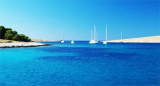
The main village, Zirje, is located in the middle of the island. A small port, luka Muna, on the coast N of Zirje, home to the ferry that connects the ...
16 Aug 11
Croatia

Otok Murter

9nm
61°
The island of Murter is the largest island of the Sibenik archipelago. It is close to the coast on which it is connected by a bridge, low air draft at Tijesno (Tisno) on the continent. During the summer the bridge opens to allow passage of boats.
The NW part of the island is fertile ...
3 Apr 11
Jojo

Vrgadski Kanal

8.7nm
28°
Vrgadski Kanal, 7 miles long, leads between Otok Murter and Otok Vrgada and is the principal channel used in the S approach to Pasmanski Kanal and Zadar.
Vessels with a maximum draft of 6.4m may pass through Pasmanski Kanal. Vessels with drafts over 6.4m must either proceed through ...
16 Jul 11
Jojo

Novigradsko More

28nm
Novigradsko More, a landlocked bay, lies at the S end of Novsko Zdrilo and provides good anchorage.
Rijeka Zrmanja flows into the bay at the E side. This river is navigable by small craft as far as the village of Obrovca, 6 miles above the mouth.
Luka Novigrad, a narrow inlet, ...
23 Jul 11
Jojo

Otok Kaprije (Sibenik)

11nm
99°
Kaprije is located in the central part of the Sibenik archipelago between the islands Zmajan and Kakan.
The highlight of the island is Vela Glavica (132 m).
The only village of the island is Kaprije, S. The port is busy.
Automobiles are not allowed on the island.
16 Aug 11
Croatia

Otocic Ravni Zakan Kornati

0nm
67°
O. Ravni Zakan is located SW of the point S of O. Kornat, betweenO. Skulj and O. Lunga at the W.
This island have two bays where anchorage is possible and a port.
18 Jul 11
Jojo