Otok Zirje
is the farthest and the largest island in the Sibenik archipelago. It is long of 6,5 NM (NW/SE) and 1,4 NM wide. The main village, Zirje, is located in the middle of the island. A small port, luka Muna, on the coast N of Zirje, home to the ferry that connects the ...
Vrgadski Kanal, 7 miles long, leads between Otok Murter and Otok Vrgada and is the principal channel used in the S approach to Pasmanski Kanal and Zadar. Vessels with a maximum draft of 6.4m may pass through Pasmanski Kanal. Vessels with drafts over 6.4m must either proceed through ...
Novigradsko More, a landlocked bay, lies at the S end of Novsko Zdrilo and provides good anchorage. Rijeka Zrmanja flows into the bay at the E side. This river is navigable by small craft as far as the village of Obrovca, 6 miles above the mouth. Luka Novigrad, a narrow inlet, ...
Kaprije is located in the central part of the Sibenik archipelago between the islands Zmajan and Kakan. The highlight of the island is Vela Glavica (132 m). The only village of the island is Kaprije, S. The port is busy. Automobiles are not allowed on the island.
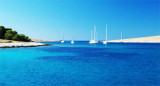
O. Ravni Zakan is located SW of the point S of O. Kornat, betweenO. Skulj and O. Lunga at the W. This island have two bays where anchorage is possible and a port.
At S Luka Rauni Zakan, in the bay
formed by the three islands (Zakanac, Jancar and Kameni Zakan) we can anchor between 13 and 4 m. Sheltered from NW wind. Depth in the passage between Jančar and Kameni Žakan is 2.6 m and
between Jančar and Žakanac 6 m. Warning: ...


 Otocic Kameni Zakan is located at SW side of O. Kornat.
 Otocic
Kameni Zakan se trouve au SW d'O. Kornat.
Otocic
Kameni Zakan se trouve au SW d'O. Kornat.")