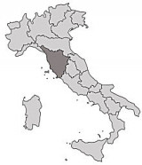

Toscana
53nm
116°
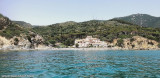
C'est la partie de la côte qui s'étend entre le cap Bianco, au S de la Spezia, et le promontoire d'Argentario et l'île de Gianutri. Le mot « Toscane » est ...
10 Jan 11
Joëlle
| Latitude | Longitude | |
| DMS | --- | --- |
| DM | --- | --- |
| DD | --- | --- |

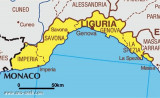
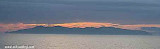
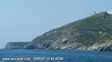
 The Ligurian Sea is an arm of the Mediterranean Sea, between the Italian Riviera (Liguria and Tuscany) and the islands of Corsica and Elba. The sea is probably named after the ancient Ligures people.
The Ligurian Sea is called "Mar Ligure" in Italian and "Mer Ligurienne" in French.
2012
Boat owners / users (including foreign visiting yachts) will be
subjected to a daily tax for the duration of their stay within Italian
waters. This will come into effect on the 1st May 2012 and the proposed
tax per day is as follows:
- €5 - from 10,01m to 12m;
- €8 - 12,01m to 14m;
- €10 - 14,01m to 17m;
- €30 - 17,01m to 24m;
- €90 - 24,01 to 34m;
- €207 - 34,01m to 44m;
- €372 - 44,01m to 54m;
- €521 - 54,01m to 64m;
- €703 - above 64m.
At present this is only a Bill that is to be presented to the Italian Parliament and is not yet law.
 Les limites arbitraires de la mer Ligure sont en général définies comme suit :
 Il mar Ligure è una parte del mar Mediterraneo centro-settentrionale. Morfologicamente è limitato ad occidente da un linea immaginaria che parte da cap Ferrat presso Nizza fino a Punta di Revellata vicino Calvi nella Corsica settentrionale, mentre il limite orientale può essere individuato tra capo Corso e il promontorio di Piombino.
Ebook | Ligure Ligurian Sea
|