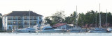
The Kochi International Marina is a marina in the city of Kochi, located in the eastern coast of the Bolgatty Island. The Kochi Marina is the only marina in India. It's a modern all-weather port and a rapidly growing maritime gateway to peninsular India.Port Control must be contacted ...
The port of Kochi (Cochin) is a fine natural harbor formed by the estuary of the Periyar River and its backwater. The inner harbor is able to shelter a large number of vessels with drafts up to 9.1m at all seasons. It is the main deep water harbor S of Bombay and a base for the ...
Alleppey (Alappuzha) lies about 29 miles S of Kochi (Cochin. The coast between the ports is low, sandy, thickly fringed with palms, and densely populated. Alleppey Light is shown from a white, round, masonry tower, about 0.3 mile E of the root of Alleppey Pier. As the town of Alleppey ...
The coast between Beypore and Ponnani, about 24 miles SSE, is low, sandy, fringed with palms, and backed by red laterite hills. A light is shown at Tanur, an important fishing village, about 11.5 miles SSE of Beypore. A tableland, covered with palms, lies about 1 mile NE of the ...
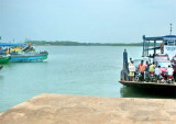
Nindakara (Neendakara) is an open roadstead port at the entrance to Ashtamudi Backwaters. At the entrance of that fishing port, two breakwaters shelter a shallow basin, with jetties on its N side where barges load ilmenite sand. The entrance can be identified from seaward by a ...
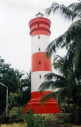
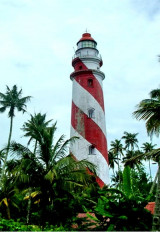
Tangasseri Point Light is shown from a concrete tower, 41m high, painted in black and white diagonal stripes, on the point. The point has been reported to be a good radar target at 17 miles. The coast from close E of Tangasseri Point to about 3 miles NNW of it is rocky with groves ...