Alleppey (Alappuzha) lies about 29 miles S of Kochi (Cochin. The coast between the ports is low, sandy, thickly fringed with palms, and densely populated.
Alleppey Light is shown from a white, round, masonry tower, about 0.3 mile E of the root of Alleppey Pier. As the town of Alleppey is difficult to distinguish from seaward, it is advisable to make a landfall while it is still dark to ensure identifying the lighthouse.
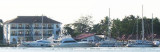
The Kochi International Marina is a marina in the city of Kochi, located in the eastern coast of the Bolgatty Island. The Kochi Marina is the only marina in India. It's a modern all-weather port and a rapidly growing maritime gateway to peninsular India.Port Control must be contacted ...
The port of Kochi (Cochin) is a fine natural harbor formed by the estuary of the Periyar River and its backwater. The inner harbor is able to shelter a large number of vessels with drafts up to 9.1m at all seasons. It is the main deep water harbor S of Bombay and a base for the ...
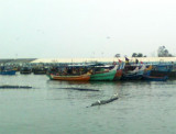
Nindakara (Neendakara) is an open roadstead port at the entrance to Ashtamudi Backwaters. At the entrance of that fishing port, two breakwaters shelter a shallow basin, with jetties on its N side where barges load ilmenite sand. The entrance can be identified from seaward by a ...
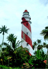
Tangasseri Point Light is shown from a concrete tower, 41m high, painted in black and white diagonal stripes, on the point. The point has been reported to be a good radar target at 17 miles. The coast from close E of Tangasseri Point to about 3 miles NNW of it is rocky with groves ...
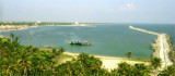
The port of Quilon (Kollam) is a small roadstead lying in the bight close SE of Tangasseri Point. The N and S limits of the port are defined by lines extending in a 247° direction from two boundary pillars. The N pillar and the S pillar lie about 0.7 mile E and 3 miles ESE, respectively, ...


 Alleppey (Alappuzha) lies about 29 miles S of Kochi (Cochin. The coast between the ports is low, sandy, thickly fringed with palms, and densely populated.
")