
Al Hamriyah (Ajman)
8nm
215°
12 Oct 11
Joëlle
| Latitude | Longitude | |
| DMS | --- | --- |
| DM | --- | --- |
| DD | --- | --- |


 Khawr Umm Al Qaywayn is an old natural coastal harbor located in the old town overlooking the traditional dhow building yard where skilled craftsmen continue to assemble these traditional boats. The harbor is surrounded by old coral stone houses that display features of the original architecture and intricate sculptured plaster work.
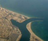
Umm al Qaywayn (Ahmed Bin Rashid) (Umm al Quwain) is located on the peninsula of Umm al Qaywayn, which is connected with the mainland W of it by a narrow isthmus about 0.1 mile wide.
Tides—Currents.—Cross-channel sets of up to 2 knots may be experienced in the approach channel.
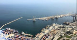
Depths—Limitations.—The port is approached through a channel, which has a minimum depth of 10m, marked by lighted buoys and lighted beacons. The approach channel is 100m wide, increasing to a width of 160m at the N end of Berth No. 4 and connecting to a turning basin, with a diameter of 500m, at the S end of Berth No. 5. 15.9 There are two berthing facilities in the port.
In winter, vessels should anchor farther offshore. The holding ground of sand and shell is poor.
Caution.—It was reported (1994) vessels should enter the port only at high tide and slack water. Currents at the intersection of the dredged channel and the turning basin may cause a vessel to be set onto the deep-water wharf.
Landing on the shores outside the inlet is usually difficult except in fine weather.
The dangerous wreck of a barge, sometimes visible at LW, lies close offshore about 0.3 mile W of Umm al Qaywayn.


Ebook | Persian Gulf - Arabian Gulf
|