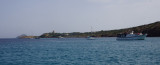

Porto Sciusciau (Sant'Antioco Sardegna)
0.3nm
209°
Anchor ...
30 Oct 12
| Latitude | Longitude | |
| DMS | --- | --- |
| DM | --- | --- |
| DD | --- | --- |

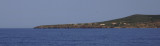
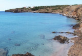
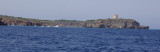
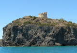
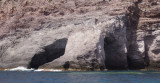
 Sant'Antioco island is rocky, with the exception of the NE coast lined with saline extending to the Sardinian coast. The island is connected to Sardinia by a causeway. She is overwhelmed by short shoals.
Sant'Antioco island is best best known for its beautiful beaches, but also for the unique archaeological site of the ancient Phoenician city of Sulcis andfor crafts linen, called "sea silk".
It is part of the archipelago of Sulcis.
 Sant'Antioco est une ile rocheuse, à l'exception de la côte NE bordée de salines se prolongeant jusqu'à la côte sarde. L'ile est reliée à la Sardaigne par une chaussée. Elle est débordée à courte distance par des hauts-fonds.
L'île est dotée de splendides petites plages mais elle est aussi célèbre pour le site archéologique de la cité Phénicienne de Sulcis et pour l'artisanat du lin, la dénommée "soie de la mer".
Elle fait partie de l'archipel des Sulcis.
 Sant'Antioco è un isola rocciosa, con l'eccezione della costa NE foderato con soluzione salina che si estende fino alla costa sarda. L'isola è collegata alla Sardegna da una strada rialzata. E 'sopraffatto da branchi.
L’isola di Sant’Antioco è nota soprattutto per le sue splendide spiaggette, ma anche per l’eccezionale sito archeologico della città fenicia di Sulcis e per l’artigianato del bisso, la cosiddetta "seta del mare".
Fa parte dell'arcipelago del Sulcis.
Ebook | Sardegna West
|