Las Hormigas (Islas Formigues) is a group of 16 rocks located at 3 NM of Palamos port, between Palafurgell of Catella and Palamos. Formed of bare rocks, almost devoid of vegetation, they can be virtually hidden when the sea is rough. This is why a light was placed on the island called Great Formiga with a range of 6 NM.
In 1285 occurred the battle of the islands Formigues, where the Aragonese fleet defeated that of France.
There is a passage between the Formigues and dangers along the coast but it is not healthy and should be avoided.
2012/06/29
Update
Jojo
Islas Hormigas ( Islas Formigues Palamos)
2012-06-29
Update
Jojo
Las Hormigas (Islas Formigues) est un groupe de 16 rochers situé à 3 MN du port de Palamos, entre Catella de Palafurgell et Palamos. Formé de roches nues, pratiquement dépourvues de végétation, ils peuvent être pratiquement caché quand la mer est mauvaise. C'est pourquoi une balise a été placée sur l'île dite de Formiga Grande avec une portée de 6 MN.
En 1285 eut lieu la bataille des îles Formigues, où la flotte des Aragonais battit celle de la France.
Il existe un passage entre Les Formigues et les dangers qui longent la côte mais il n'est pas sain et doit être évité.
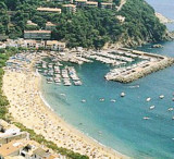
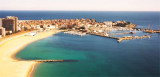
Palamos bay is limited W by Cabo de Rocas Planas and E Punta de Palamos or del Molino.Palamos harbour lies in the NE part of the bay.Dangers: a rock with a depth of 3,4 m (Lloja or Loja de Palamos) lies about 0,5 NM SW of Punta del Molino and is marked by a lighted beacon.
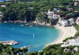
Located between Punta d'en Planch and Cabo San Sebastian, the small Llafranc cove is bordered by a beautiful sandy beach and offers on its E side the Llafranc yacht club.
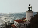
Llafranc is characterized by the presence of Sant Sebastian cape, who sits on the rocky cliffs that protect the marina. We can see the old watchtower which dates from 1445, the hermitage of Sant Sebastian and the lighthouse of the same name, which it, dates 1857. Port protects ...
Cabo Gros, à l'E de la baie de Palamos, est un promontoire escarpé. La côte qui lui fait suite jusqu'au cap San Sebastian, présente une succession d'anses séparées par des pointes. Les plus importantes, qui servent d'abri pour les navires côtiers, sont près du cap Gros et ...


 Las Hormigas (Islas Formigues) is a group of 16 rocks located at 3 NM of Palamos port, between Palafurgell of Catella and Palamos.
")
 Las Hormigas (Islas Formigues) est un groupe de 16 rochers situé à 3 MN du port de Palamos, entre Catella de Palafurgell et Palamos.
 ")