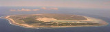
Europa Island (French: Île Europa) is a 30 km² tropical island in the Mozambique Channel. Anchorage is possible offshore. Europa Island is a nature reserve and host to migratory seabirds. It is one of the world's largest nesting sites for green turtles (Chelonia mydas). ...
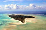
Bassas da India, situé à 21 ° 30'S, 39 ° 50'E, forment un groupe d'îles inhabitées de l'Océan Indien, au large de la côte sud de l'Afrique, dans le sud du canal de Mozambique , à mi-chemin entre Madagascar et le Mozambique . Leur superficie s'élève à 0,2 km ², avec ...


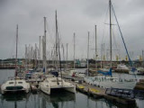
 Port pour Ferry.
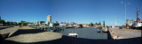
 Ferry jetee.