Ile de Keller

Ile de Keller

To precisely geolocate this site. Update if necessary.

Localisation

Ile de Keller
LatitudeLongitude
DMS------
DM------
DD------

Characteristics

Island / Atoll

Description

 
Île privée  au nord d'Ouessant.
2010/11/14
Update
Ebook

Iroise

  • 123 sites
  • 83 photos
  • publication date: 8 Jul 2023
  • .pdf file size: 79 Mb
Share your comments or photos on "Ile de Keller"

Sites around Ile de Keller

Flying distances - Direct line

Baie de Calgrac'h

0.7nm
163°
A l'ouest de la grande baie de Beninou, se trouve la baie de Calgrac'h offrant un mouillage à quelques bateaux ainsi qu'une cale de mise à l'eau.
8 May 12
Geof

Plage de Yuzin

1.1nm
205°
Plage de Yuzin ou le port de "Ar Yusin" offre une petite zone de mouillage protégée de l'Est ainsi qu'une cale de mise à l'eau.
8 May 12
Geof

Porspaul

1.9nm
181°
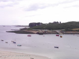
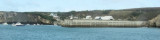
Petit port et zone de mouillage au sud de Lampaul (en fond de baie) bien protégé de l'E et du N. Vu l'orientation de la baie, le SW rend par contre le mouillage désagréable.

8 May 12
Geof

Phare et Vigie du Stiff

1.8nm
111°
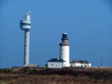
Le Stiff Light is shown from a conspicuous structure formed by two adjoining towers, 32m high, standing near Pointe du Stiff, the NE extremity of the island. A prominent signal station tower (Vigie du Stiff), 72m high, is situated 0.3 mile NE of this light.
8 May 12
Geof

Porz Ligoudou - Gare Maritime

1.9nm
126°
Différentes appelations:
Pors Ligoudou = Porzh Liboudou = Port aux mares de boueMouillage en fond de baie de Stiff à coté de la gare maritime.
8 May 12
Geof

Phare du Créac'h

2.1nm
218°
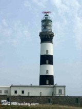
Creac’h Light  is shown from a conspicuous tower, 55m high, standing on Pointe de Creac’h, near the W end of the island. A racon is situated at this light, but it can only be used by vessels passing NW of the island.
8 May 12
Geof