Haa-Alifu ou Ihavandiffulu Atoll

Haa-Alifu ou Ihavandiffulu Atoll

To precisely geolocate this site. Update if necessary.

Localisation

Haa-Alifu ou Ihavandiffulu Atoll
LatitudeLongitude
DMS------
DM------
DD------

Characteristics

Coast
Restaurant
Beach
Sand
Diving

Description

Haa-Alifu ou Ihavandiffulu Atoll
Haa-Alifu Atoll
2008-01-07
Update
Ebook

Maldives

  • 128 sites
  • 118 photos
  • publication date: 9 Jul 2023
  • .pdf file size: 19 Mb
Ihavandiffulu Atoll is the N atoll of the Maldive islands.
It is divided into two administrative areas: Alifu Alifu N and S.
The Ari atoll, one of the largest in the Maldives with its 80km long and 30km wide, is divided into two administrative areas: Alifu Alifu N and S.
Ari N also includes two small atolls Rasdhoo (9 km in diameter) and Thoddoo. Its capital Rasdhoo Island, while Ari S Mahibadhoo's capital.
Thodhoo is known through all the Maldives for its watermelons, but also to archaeological discoveries have been made in 1958, which revealed that the island was an important Buddhist center of the country before converting to Islam.
The atoll consists of about 70 islands of which 18 are inhabited and 25 of which are devoted to tourism. Most of these islands in the atoll are large with abundant vegetation and what is not common, they are all located on the outer parts of the atoll.
In the E half of the lagoon depths are 37 to 55m and from 18.3 to 37 m in the W half of the lagoon. Many shoals in the lagoon are particular in the W. These shoals, when the sun rises, can be recognized by their pale green contrasting with the dark tone of deeper water, they are not easily visible if the sky is overcast.
The main occupations are fishing and the cultivation of coconuts, most of the islands being heavily wooded with palms.
Currents at Ihavandiffulu Atoll are only experienced occasionally and are probably influenced entirely by local weather conditions. There appears to be no regular tidalcurrents.A current of 2 knots setting N was experienced about 50 miles E of the atoll (December), but practically no current in this position was experienced about a month later.During December and January in the offing, the current generally sets N or W, but it is irregular.A set to NW between Uleguma and Wagaru, and to W between Uleguma and Murdu, was sometimes observed. The maximum velocity was about 1 knot. In the middle of the lagoon there was an occasional set to NW.Vessels approaching from N enter through North Rock Passage, between Wagaru and North Rock, 1 mile W; through North Western Entrance, between Wagaru and Turakana; or through Northern Entrance, between Turakana and Ulegama.North Rock Passage may be entered in depths of not less than 18.3m by keeping towards Wagaru; the other entrances have depths of not less than 20.1m in the fairway midway between the islands, but there are shallower depths close within the lagoon in the Northern Entrance. The edges of the reefs on each side of the passage can be seen from aloft at a good distance.Vessels approaching from E use North Eastern Entrance between Ulegama and Murdu, about 1.8 miles SE, or East Entrance between Muladu and Gallandu. North Eastern Entrance has a least depth of 35m midway between the islands.In East Entrance, there is a shoal patch midway between the flanking islands and a second patch farther SSW. If using this entrance, bring the NE end of Medfuri to bear 287° and enter the lagoon on this heading. When the S end of Muladu bears 070°, steer for the N end of Hauwandu bearing 250°, and then to the anchorage off that island.Caution.—Collingrufuri, Medufuri, and Manafur, three islands surrounded by rocky heads, foul ground, and shoal water, lie about 3.3 and 3 miles N, and 2.3 miles NNE, respectively, of Ihavandu. Two drying rocks lie on a rocky shoal close N of Medufuri.Endeavour Shoal, a large coral patch with a least depth of 6.1m, lies about 3.3 miles SSW of Uleguma.Ormonde Rock, with a least depth of 4.6m, lies about 2 miles SW of Ulegama.In addition, there are numerous shoals and rocky patches in the lagoon, particularly toward the NW and SW sides; under suitable conditions all can be easily seen from aloft.
2011/11/3
Update
JB Antibes
Ihavandiffulu Atoll est l'atoll N des îles Maldives.
Il est séparé en deux zones administratives: Alifu N et Alifu S. 
L'atoll d'Ari, l'un des plus vastes des Maldives avec ses 80km de long et 30km de large est séparé en deux zones administratives: Alifu N et Alifu S.
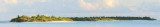
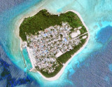
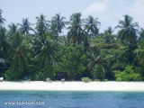
Ari N comprend également les deux petits atolls de Rasdhoo (9 km de diamètre) et de Thoddoo. Il a pour capitale l'île de Rasdhoo, alors qu'Ari S a pour capitale Mahibadhoo.Thodhoo est réputé à travers toutes les Maldives pour ses pastèques, mais également pour les découvertes archéologiques qui y ont été faites en 1958, lesquelles révélèrent que l'île était un important centre bouddhiste avant la conversion du pays à l'Islam. L'atoll comprend environ 70 îles dont 18 sont habitées et dont 25 sont consacrées au tourisme. La plupart de ces îles, dans l'atoll, sont grandes avec une végétation abondante et, ce qui n'est pas courant, elles sont toutes situées sur le versant extérieur de l'atoll.Dans la moitié E du lagon les profondeurs sont de 37 à 55m et de 18,3 à 37 m dans la moitié W du lagon. De nombreux hauts-fonds se trouvent dans le lagon et notamment dans la partie W. Ces hauts-fonds, lorsque le soleil se lève, peuvent être reconnus grâce à leur couleur vert pâle contrastant avec le ton foncé de l'eau plus profonde; ils ne sont pas facilement visibles si le ciel est couvert.La principale occupation est la pêche et la culture des noix de coco, la majorité des îles sont couvertes de palmiers.
Les courants sur l'atoll Ihavandiffulu sont probablement entièrement influencés par le temps local. 
Un courant de 2 noeuds venant du N a été relevé en décembre, à environ 50 NM à l'E de l'atoll, mais pratiquement aucun courant dans cette zone, n'a été observé un mois plus tard.Pendant les mois de décembre et de janvier le courant vient du N ou de l'W, mais est irrégulier.Les navires qui approchent l'atoll par le N entrent par le North Rock Passage, entre Wagaru et North Rock, à 1 mile à l'W; par l'entrée Nord-Ouest, entre Wagaru et Turakana, ou par l'entrée Nord, entre Turakana et Ulegama.
North Rock Passage est profond d'au moins 18,3 m en longeant Wagaru; les autres entrées ont des profondeurs d'au moins 20,1 dans le milieu de parcours entre les îles, mais il ya des profondeurs plus faibles à proximité de la lagune dans l'entrée Nord. Les bords des récifs de chaque côté du passage peuvent être vu à une bonne distance.
Les navires qui approchent par l'E utilisent l'entrée Nord Est entre Ulegama et Murdu, à environ 1,8 miles au SE, ou à l'entrée Est entre Muladu et Gallandu.
L'entrée Nord-Est a une profondeur minimale de 35m à mi-chemin entre les îles.
Dans l'entrée Est, il ya un haut-fond à mi-chemin entre les îles et un second haut-fond plus loin au SSW. Si vous utilisez cette entrée, passer à l'extrémité NE de Medfuri en navigant au 287 ° et entrer dans le lagon. A l'extrémité S de Muladu prendre le 070 °, faire cap sur l'extrémité N de Hauwandu au 250 °, puis mouiller en face de cette île.
Attention.-Collingrufuri, Medufuri et Manafur, ces trois îles sont entourées par des têtes rocheuses, des eaux peu profondes, et se situent à environ 3,3 et 3 milesau  N et  2.3 miles au NNE, respectivement, de Ihavandu. Deux rochers émergés se trouvent sur ​​un haut-fond rocheux proches au N de Medufuri.
Un courant de NW entre Uleguma et Wagaru, et d'W entre Uleguma et Murdu, a été observé quelquefois. La vitesse maximum est d'environ 1 noeud. Au milieu du lagon il y a occasionnellement un courant de NW.
Endeavour Shoal, un haut-fond de corail avec une profondeur minimale de 6,1 m, se trouve à environ 3,3 miles au SSW de Uleguma.
Ormonde Rock, avec une profondeur minimale de 4,6 m, se trouve à environ 2 miles au SW de Ulegama.
En outre, il y a nombreux bancs rocheux dans le lagon, en particulier vers le NW et SW; dans des conditions appropriées tout peut être facilement vu depuis la mâture.
2011/11/3
Update
JB Antibes
Share your comments or photos on "Haa-Alifu ou Ihavandiffulu Atoll"

Sites around Haa-Alifu ou Ihavandiffulu Atoll

Flying distances - Direct line

Barrier reef of Ihavandiffulu atoll

5.6nm
328°
Hauwandu, about 0.8 mile W of Ihavandu, lies at the SE end of a section of the barrier reef which extends about 9 miles NW, then 3 miles NE; of the eight islands and islets on this stretch of reef, Umbala and Hatefuri were inhabited in 1970.
Umbala, with a large ...
22 Oct 11
Joëlle

Kelai (N Tiladummati)

16nm
89°
Kelai, at the NE extremity of the atoll, was inhabited in 1970. Good radar returns have been reported from Kelai at 14 miles. The islet of Tinadu lies about 3 miles WSW of Kelai.
25 Oct 11
JB Antibes

Maduni Faro (N Tiladummati)

7.9nm
142°
Maduni Faro, a lagoon reef, forms the NW extremity of the atoll.
The islets of Marandu, Tukandu, and Miledu, the first two inhabited in 1970, lie, respectively, on the barrier reef between the N end of Maduni Faro and the islet of Gafuri, about 5 miles ESE. Gafuri ...
25 Oct 11
Joëlle

Digufuri reef (Ihavandiffulu)

2.7nm
115°
Digufuri Reef (Digfurhi Reef), at the S end of Ihavandiffulu Atoll, has an islet at its E end; a small sandbank, with palms on it, lies about 0.8 mile ENE of the islet.
21 Oct 11
Joëlle

Warifuri Faro (N Tiladummati)

14nm
98°
Warifuri Faro is a large lagoon with the islet of Warifuri at its S end. A lighted beacon lies on the N side of Warifuri Faro. The islets of Dedu and Warifuri are inhabited; the islet of Noradu lies between the latter two islets.
25 Oct 11
Joëlle

Ihavandhoo (Ihavandiffulu)

1.5nm
66°
Ihavandu, one of the few islands within the lagoon, lies close N of Digufuri Reef and about 3 miles W of Gallandu.
The island is densely populated, and there is a landing on the S side.
21 Oct 11
JB Antibes