Golfe de Valence (Costa Blanca)

Golfe de Valence (Costa Blanca)

To precisely geolocate this site. Update if necessary.

Localisation

Golfe de Valence (Costa Blanca)
LatitudeLongitude
DMS------
DM------
DD------

Characteristics

Coast

Description

N San Antonio cape,  the coast forms the Gulf of Valencia, very large opening, which extends to Oropesa cape, N at 78 MN.

The coast is rocky at first and at lower altitudes, down to E of Denia.

Valencia, one of the largest cities in Spain, built in the middle of a plain, is located 2 NM from the coast.

The port is entirely artificial, it offers all-weather safe shelter.

Currents: Offshore winds rise the water level in the harbor up to 0.3 m . Off the port, the current runs in S.

The bay is uncrowded for mooring because it is dangerous especially in winter, with the winds from seaward.
When necessary, the best anchorage is located approximately 0.5 NM N of the N breakwater of the port of Valencia, by 12 to 15 m.


2012/05/25
Update
Jojo
Au N du Cap San Antonio, la côte dessine le Golfe de Valence, de très large ouverture, qui s'étend jusqu'au Cap d'Oropesa, à 78 MN au N.

La côte est d'abord rocheuse et d'altitude décroissante jusque dans l'E de Denia. 

Valence, une des plus grandes villes d'Espagne, construite au milieu d'une plaine, est située à 2 MN de la côte.

Le port est entièrement artificiel, il offre par tous temps un abri sûr.

Courants: Les vents du large font monter de 0,3 m le niveau de l'eau dans le port. Au large du port, le courant porte au S.

La rade est peu fréquentée pour le mouillage car elle est dangereuse surtout en hiver, avec les vents portant en côte.
En cas de nécessité, le meilleur mouillage se trouve à 0,5 MN environ au N de la digue N du port de Valence, par 12 à 15 m.

2012/05/24
Update
Jojo
Ebook

Espagne Est - East Spain

  • 235 sites
  • 414 photos
  • publication date: 7 Jul 2023
  • .pdf file size: 180 Mb
Share your comments or photos on "Golfe de Valence (Costa Blanca)"

Sites around Golfe de Valence (Costa Blanca)

Flying distances - Direct line

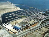
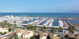
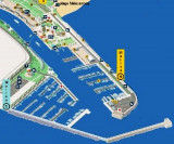
Puerto America's Cup Marina de Valencia (C. Valenciana)

1.3nm
269°
The marina is situated in N of the trading port and in the S of Malavarrosa beach, in the center of Valencia.
The harbour is entirely artificial and provides all-weather safe shelter for ships of any tonnage.Reception in front of harbourmaster's office, on the right.T. 963 ...
19 May 12
Jojo

Real club nautico de Valencia (C. valenciana)

2.4nm
214°
The pleasure craft harbour is situated at the root of the S breakwater, outside the commercial harbour, at about 4 km from the city of Valencia.Approach: 2450 m dreged channel orientated NW/SE, with lightened buoys on SW. Danger: light spec. marked buoys, 1,5 NM in NE of Valencia ...
19 May 12
Jojo

Saplaya Marina (C. de Azahar)

3.2nm
340°
Saplaya Marina, also known as Puerto de Alboraya, is a purpose built marina just to the north of Valencia on the E coast of Spain. 
Approach and entry are easy in all but strong winds and swell from the N - SE when it could be dangerous. 
Shelter is good once inside.
T. ...
25 May 12
Jojo

Farnals Pobla Marina (C. del Azahar)

6nm
The Pobla marina is situated on the Costa del Azahar,  5 NM only  of the city of Valencia (home of the 32nd AMERICA'S CUP).T. 961 463 223
686 pl. (<18 m) Port began an expansion of its facilities which are planned for 1285 berths of lengths between 12 and 40 meters.
25 May 12
Jojo

Algar de Almadraba (C Valenciana)

37nm
157°
Algar de la Almadraba, centered about 6 miles NW of Denia, is an extensive area of foul ground which lies off this stretch of coast. This area has depths of 25 to 36m and heavy seas are raised over it by onshore winds.
23 May 12
Jojo

Rada de Cullera (C Valenciana)

17nm
168°
The harbor of Cullera extends from the mouth of the Rio Jucar to the rock of Los Pensiamentos, S Cape Cullera.
23 May 12
Jojo