Frederikssund Harbour

Frederikssund Harbour

To precisely geolocate this site. Update if necessary.

Localisation

Frederikssund Harbour
LatitudeLongitude
DMS------
DM------
DD------

Characteristics

Port

Description

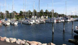
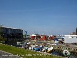
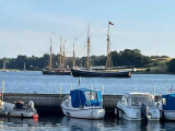
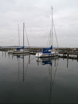
The Frederikssund Marina is situated just beside the outdoor site of the annual Frederikssund viking play and the Frederikssund Viking
Settlement with its historically correct replicas of Viking buildings.
2010/09/29
Update
Frederikssund Harbour
2010:09:23 11:15:35
2010-09-29
Update
Anonymous
Frederikssund Harbour
2010:09:23 11:15:39
2010-09-29
Update
Anonymous
Ebook

Kattegat

  • 32 sites
  • 27 photos
  • publication date: 8 Jul 2023
  • .pdf file size: 36 Mb
Share your comments or photos on "Frederikssund Harbour"

Sites around Frederikssund Harbour

Flying distances - Direct line

Veddelev Beach Harbour

9.4nm
177°
Donnez ici des explications sur le site. Vous pouvez y mettre du texte ou des images.
1 Oct 10
Toto 7

Frederiksvaerk

7.8nm
345°
Small port protected by a breakwater.
30 Jul 11
sdobing

Gershøj

7.5nm
199°
Provide here details of the site. You can put text or images.
1 Oct 10
Toto 7

Roskilde Harbour

11nm
176°
The harbour is situated at the bottom of Roskilde FjordThere are plenty of activities at the marina and the adjacent museum of Viking boats and its harbour
The harbour provides the following facilities: Diesel supply, slip-way, crane, rigging-sheers, BBQ area, playground, ...
15 Jul 11
Agien

Herslev

9.7nm
193°
Provide here details of the site. You can put text or images.
1 Oct 10
Toto 7